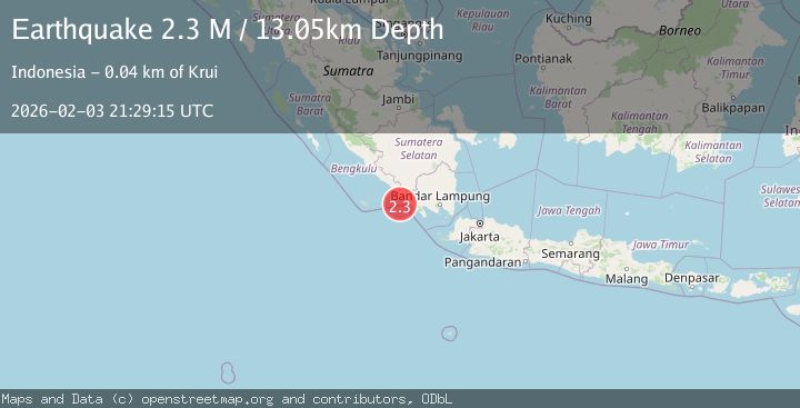
Earthquake Southern Sumatra, Indonesia
Tue, 03 Feb 2026 21:29:18 GMT
Time18 hours ago
Location
-5.3809, 103.7874
Depth
33.8 KM
Event Summary
A 2.0 magnitude earthquake struck on Southern Sumatra, Indonesia, at Tue, 03 Feb 2026 21:29:18 GMT. Depth: 33.793327km. Reviewed by BMKG seismologists, this minor quake occurred at a magnitude type of M.
Magnitude
2.0
M
Source
BMKG
Intensity
-
Agency Reports
1 Sources| Source | Magnitude | Depth | Time |
|---|---|---|---|
| BMKGPrimary | 2.0 | 34 km | 18 hours ago |
Earthquake Details
AutomaticEvent IDbmg2026cjyd
Tsunami PotentialNo
Magnitude TypeM
Nearest Places
- Padangnegeri22.3 km
- Ujung Walor22.3 km
- Desa Suka Jadi22.3 km
- Lintik22.4 km
- Desa Walur22.5 km
Comments
Join the discussion about this event.
Latest Earthquakes
1.8Mag
21 km NNE of Indio, CA
Time18 hours ago
Depth5.49 km
SourceUSGS (Automatic)
1.7Mag
22 km N of Ridgecrest, CA
Time19 hours ago
Depth7.95 km
SourceUSGS (Automatic)
1.0Mag
WESTERN TURKEY
Time19 hours ago
Depth12.70 km
SourceAFAD (Automatic)
2.1Mag
Java, Indonesia
Time19 hours ago
Depth10.00 km
SourceBMKG (Automatic)
1.4Mag
EASTERN TURKEY
Time19 hours ago
Depth7.00 km
SourceEMSC (Automatic)
Nearby Earthquakes
2.7Mag
Southern Sumatra, Indonesia
Time1 week ago
Depth27.97 km
SourceBMKG (Automatic)
2.5Mag
Southern Sumatra, Indonesia
Time4 days ago
Depth100.12 km
SourceBMKG (Automatic)
3.0Mag
Southern Sumatra, Indonesia
Time2 days ago
Depth5.00 km
SourceBMKG (Automatic)
2.9Mag
Southern Sumatra, Indonesia
Time1 week ago
Depth22.12 km
SourceBMKG (Automatic)
2.6Mag
Southern Sumatra, Indonesia
Time5 days ago
Depth18.59 km
SourceBMKG (Automatic)