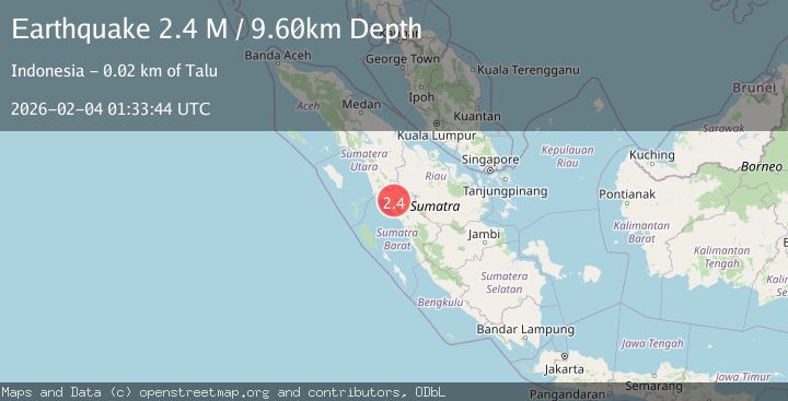
Earthquake Northern Sumatra, Indonesia
Wed, 04 Feb 2026 01:33:43 GMT
Time13 hours ago
Location
0.0758, 99.9916
Depth
12.8 KM
Event Summary
A 2.3 magnitude earthquake struck on Northern Sumatra, Indonesia, at Wed, 04 Feb 2026 01:33:43 GMT. Depth: 12.820345km. Reviewed by BMKG seismologists, this minor quake occurred at a magnitude type of M.
Magnitude
2.3
M
Source
BMKG
Intensity
-
Agency Reports
1 Sources| Source | Magnitude | Depth | Time |
|---|---|---|---|
| BMKGPrimary | 2.3 | 13 km | 13 hours ago |
Earthquake Details
AutomaticEvent IDbmg2026ckgf
Tsunami PotentialNo
Magnitude TypeM
Nearest Places
- Gunung Ophir0.9 km
- Batubaringkok6.1 km
- Gunggung6.2 km
- Bukit Rangkiang6.2 km
- Pamatanggugung6.6 km
Comments
Join the discussion about this event.
Latest Earthquakes
1.0Mag
85 km NNW of Karluk, Alaska
Time13 hours ago
Depth5.00 km
SourceUSGS (Automatic)
1.7Mag
5 km NE of Muscoy, CA
Time13 hours ago
Depth7.58 km
SourceUSGS (Automatic)
1.2Mag
NORTHERN ITALY
Time13 hours ago
Depth12.00 km
SourceOGS (Automatic)
1.3Mag
22 km S of Simmler, CA
Time13 hours ago
Depth7.89 km
SourceUSGS (Automatic)
2.7Mag
Sumbawa Region, Indonesia
Time13 hours ago
Depth31.43 km
SourceBMKG (Automatic)
Nearby Earthquakes
2.5Mag
NORTHERN SUMATRA, INDONESIA
Time1 week ago
Depth8.00 km
SourceBMKG (Automatic)
2.7Mag
Northern Sumatra, Indonesia
Time6 days ago
Depth14.71 km
SourceBMKG (Automatic)
2.1Mag
Southern Sumatra, Indonesia
Time5 days ago
Depth17.85 km
SourceBMKG (Automatic)
2.4Mag
Southern Sumatra, Indonesia
Time1 day ago
Depth10.00 km
SourceBMKG (Automatic)
2.9Mag
Northern Sumatra, Indonesia
Time1 week ago
Depth139.67 km
SourceBMKG (Automatic)