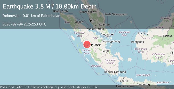
Earthquake Southern Sumatra, Indonesia
Wed, 04 Feb 2026 21:52:53 GMT
Time1 hour ago
Location
-0.1402, 100.1925
Depth
10.0 KM
Event Summary
A 3.8 magnitude earthquake struck on Southern Sumatra, Indonesia, at Wed, 04 Feb 2026 21:52:53 GMT. Depth: 10km. Reviewed by BMKG seismologists, this minor quake occurred at a magnitude type of M.
Magnitude
3.8
M
Source
BMKG
Intensity
-
Agency Reports
1 Sources| Source | Magnitude | Depth | Time |
|---|---|---|---|
| BMKGPrimary | 3.8 | 10 km | 1 hour ago |
Earthquake Details
AutomaticEvent IDbmg2026cluk
Tsunami PotentialNo
Magnitude TypeM
Nearest Places
- Kotatinggi1.9 km
- Tantaman2.7 km
- Bukit Tampunik3.5 km
- Kecamatan Palembayan3.5 km
- Air Limaupaka3.6 km
Comments
Join the discussion about this event.
Latest Earthquakes
1.5Mag
NORTHERN ITALY
Time2 hours ago
Depth6.10 km
SourceETHZ (Automatic)
1.7Mag
42 km ESE of Knik River, Alaska
Time2 hours ago
Depth29.20 km
SourceUSGS (Automatic)
4.7Mag
Mindanao, Philippines
Time2 hours ago
Depth10.00 km
SourceBMKG (Automatic)
3.0Mag
Minahassa Peninsula, Sulawesi
Time2 hours ago
Depth113.48 km
SourceBMKG (Automatic)
1.7Mag
8 km N of Ventura, CA
Time2 hours ago
Depth6.04 km
SourceUSGS (Automatic)
Nearby Earthquakes
2.4Mag
Southern Sumatra, Indonesia
Time2 days ago
Depth10.00 km
SourceBMKG (Automatic)
2.1Mag
Southern Sumatra, Indonesia
Time5 days ago
Depth17.85 km
SourceBMKG (Automatic)
2.7Mag
Northern Sumatra, Indonesia
Time6 days ago
Depth14.71 km
SourceBMKG (Automatic)
2.4Mag
Northern Sumatra, Indonesia
Time22 hours ago
Depth9.60 km
SourceBMKG (Automatic)
2.5Mag
NORTHERN SUMATRA, INDONESIA
Time1 week ago
Depth8.00 km
SourceBMKG (Automatic)