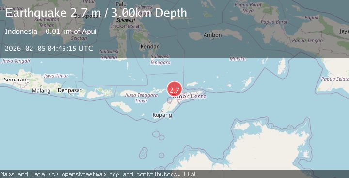
Earthquake Timor Region
Thu, 05 Feb 2026 04:45:14 GMT
Time1 hour ago
Location
-8.2170, 124.7751
Depth
10.0 KM
Event Summary
A 2.6 magnitude earthquake struck on Timor Region, at Thu, 05 Feb 2026 04:45:14 GMT. Depth: 10km. Reviewed by BMKG seismologists, this minor quake occurred at a magnitude type of M.
Magnitude
2.6
M
Source
BMKG
Intensity
-
Agency Reports
1 Sources| Source | Magnitude | Depth | Time |
|---|---|---|---|
| BMKGPrimary | 2.6 | 10 km | 1 hour ago |
Earthquake Details
AutomaticEvent IDbmg2026cmia
Tsunami PotentialNo
Magnitude TypeM
Nearest Places
- Poang1.5 km
- Waisika2.0 km
- Lompui2.2 km
- Desa Waisika2.3 km
- Dola Umang2.5 km
Comments
Join the discussion about this event.
Latest Earthquakes
1.3Mag
17 km S of Tres Pinos, CA
Time1 hour ago
Depth6.61 km
SourceUSGS (Automatic)
4.5Mag
Mindanao, Philippines
Time1 hour ago
Depth525.62 km
SourceBMKG (Automatic)
0.8Mag
8 km W of Cobb, CA
Time2 hours ago
Depth2.25 km
SourceUSGS (Automatic)
1.6Mag
19 km S of Westbrook, Texas
Time2 hours ago
Depth2.17 km
SourceUSGS (Automatic)
0.9Mag
FINLAND
Time2 hours ago
Depth0.00 km
SourceISF (Automatic)
Nearby Earthquakes
2.1Mag
Timor Region
Time2 days ago
Depth11.36 km
SourceBMKG (Automatic)
2.5Mag
Timor Region
Time1 day ago
Depth21.54 km
SourceBMKG (Automatic)
2.0Mag
Timor Region
Time1 week ago
Depth21.90 km
SourceBMKG (Automatic)
3.2Mag
KEPULAUAN ALOR, INDONESIA
Time1 week ago
Depth208.00 km
SourceBMKG (Automatic)
3.0Mag
Timor Region
Time22 hours ago
Depth31.54 km
SourceBMKG (Automatic)