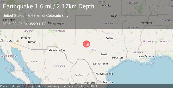
Earthquake 19 km S of Westbrook, Texas
Thu, 05 Feb 2026 04:08:29 GMT
Time2 hours ago
Location
32.1830, -101.0020
Depth
2.2 KM
Event Summary
A 1.6 magnitude earthquake struck on 19 km S of Westbrook, Texas, at Thu, 05 Feb 2026 04:08:29 GMT. Depth: 2.1745km. Reviewed by USGS seismologists, this minor quake occurred at a magnitude type of ml.
Magnitude
1.6
ml
Source
USGS
Intensity
-
Agency Reports
1 Sources| Source | Magnitude | Depth | Time |
|---|---|---|---|
| USGSPrimary | 1.6 | 2 km | 2 hours ago |
Earthquake Details
AutomaticEvent IDusgs_tx2026cmoqxr
Tsunami PotentialNo
Magnitude Typeml
Nearest Places
- Calf Creek Tank0.3 km
- Vowell Tank1.9 km
- Wildcat Tank2.0 km
- Wildcat Creek2.3 km
- Dry Hollow Creek2.5 km
Comments
Join the discussion about this event.
Latest Earthquakes
2.6Mag
WESTERN TEXAS
Time6 minutes ago
Depth1.60 km
SourceTX (Automatic)
2.3Mag
CROATIA
Time15 minutes ago
Depth1.20 km
SourceARSO (Automatic)
2.8Mag
Sumbawa Region, Indonesia
Time18 minutes ago
Depth14.64 km
SourceBMKG (Automatic)
2.1Mag
NORTHERN ITALY
Time19 minutes ago
Depth25.20 km
SourceINGV (Automatic)
2.3Mag
SAN FRANCISCO BAY AREA, CALIF.
Time19 minutes ago
Depth3.10 km
SourceNC (Automatic)
Nearby Earthquakes
1.8Mag
25 km S of Westbrook, Texas
Time1 week ago
Depth2.05 km
SourceUSGS (Automatic)
1.8Mag
26 km S of Westbrook, Texas
Time1 week ago
Depth2.88 km
SourceUSGS (Automatic)
1.7Mag
27 km S of Westbrook, Texas
Time1 week ago
Depth4.23 km
SourceUSGS (Automatic)
2.6Mag
WESTERN TEXAS
Time6 minutes ago
Depth1.60 km
SourceTX (Automatic)
1.9Mag
10 km S of Forsan, Texas
Time1 week ago
Depth0.90 km
SourceUSGS (Automatic)