Earthquake Banda Sea
Thu, 05 Feb 2026 14:26:23 GMT
Time4 days ago
Location
-7.5226, 128.7028
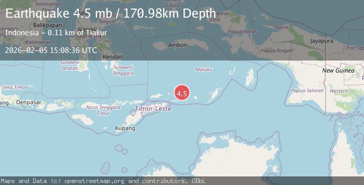
Depth
195.8 KM
Event Summary
A 4.6 magnitude earthquake struck on Banda Sea, at Thu, 05 Feb 2026 14:26:23 GMT. Depth: 195.764099km. Reviewed by BMKG seismologists, this light quake occurred at a magnitude type of M.
Magnitude
4.6
M
Source
BMKG
Intensity
-
Agency Reports
2 Sources| Source | Magnitude | Depth | Time |
|---|---|---|---|
| BMKGPrimary | 4.6 | 151 km | 4 days ago |
| USGS | 4.5 | 171 km | 4 days ago |
Earthquake Details
AutomaticEvent IDbmg2026cnbe
Tsunami PotentialNo
Magnitude TypeM
Nearest Places
- Pulau Terbang Selatan23.3 km
- Pulau Terbang Utara29.4 km
- Tanjung Paran34.6 km
- Tanjung Watlewantutu35.5 km
- Desa Wulur38.6 km
Comments
Join the discussion about this event.
Latest Earthquakes
3.2Mag
OFFSHORE COQUIMBO, CHILE
Time5 minutes ago
Depth23.90 km
SourceCSN (Automatic)
3.9Mag
West Papua Region, Indonesia
Time5 minutes ago
Depth20.40 km
SourceBMKG (Automatic)
3.3Mag
NORTH ISLAND OF NEW ZEALAND
Time17 minutes ago
Depth17.00 km
SourceGNS (Automatic)
4.5Mag
MORO GULF, MINDANAO, PHILIPPINES
Time17 minutes ago
Depth35.00 km
SourcePIVS (Automatic)
4.6Mag
Mindanao, Philippines
Time18 minutes ago
Depth10.00 km
SourceBMKG (Automatic)
Nearby Earthquakes
5.0Mag
Banda Sea
Time1 week ago
Depth160.88 km
SourceBMKG (Automatic)
4.2Mag
Banda Sea
Time5 days ago
Depth190.86 km
SourceBMKG (Automatic)
3.8Mag
Banda Sea
Time2 weeks ago
Depth199.25 km
SourceBMKG (Automatic)
3.6Mag
KEPULAUAN BARAT DAYA, INDONESIA
Time1 week ago
Depth172.00 km
SourceBMKG (Automatic)
3.9Mag
Banda Sea
Time3 hours ago
Depth191.34 km
SourceBMKG (Automatic)