Earthquake Tanimbar Islands Region, Indonesia
Fri, 06 Feb 2026 22:48:48 GMT
Time1 hour ago
Location
-7.7732, 130.3564
Depth
137.6 KM
Event Summary
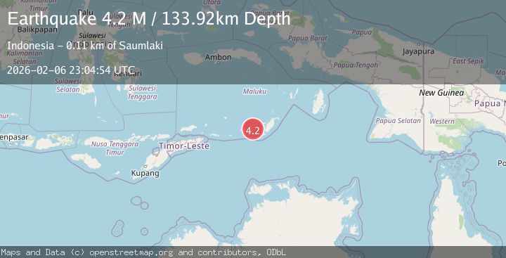
A 4.2 magnitude earthquake struck on Tanimbar Islands Region, Indonesia, at Fri, 06 Feb 2026 22:48:48 GMT. Depth: 137.602142km. Reviewed by BMKG seismologists, this light quake occurred at a magnitude type of M.
Magnitude
4.2
M
Source
BMKG
Intensity
-
Agency Reports
1 Sources| Source | Magnitude | Depth | Time |
|---|---|---|---|
| BMKGPrimary | 4.2 | 134 km | 1 hour ago |
Earthquake Details
AutomaticEvent IDbmg2026cpng
Tsunami PotentialNo
Magnitude TypeM
Nearest Places
- Desa Wiratan30.5 km
- Desa Nurnyaman30.7 km
- Nurnyaman31.3 km
- Pulau Daweloor31.5 km
- Kecamatan Dawelor Dawera31.6 km
Comments
Join the discussion about this event.
Latest Earthquakes
3.3Mag
MOROCCO
Time10 minutes ago
Depth10.00 km
SourceIGN (Automatic)
2.6Mag
47 km NW of San Antonio, Puerto Rico
Time25 minutes ago
Depth21.25 km
SourceUSGS
2.7Mag
OFF COAST OF COSTA RICA
Time28 minutes ago
Depth14.00 km
SourceUNA (Automatic)
1.5Mag
TURKEY-SYRIA BORDER REGION
Time32 minutes ago
Depth7.00 km
SourceEMSC (Automatic)
3.0Mag
STRAIT OF GIBRALTAR
Time36 minutes ago
Depth13.40 km
SourceIGN (Automatic)
Nearby Earthquakes
5.9Mag
Tanimbar Islands Region, Indonesia
Time3 hours ago
Depth100.00 km
SourceBMKG (Automatic)
3.6Mag
Tanimbar Islands Region, Indonesia
Time1 week ago
Depth224.21 km
SourceBMKG (Automatic)
5.0Mag
Tanimbar Islands Region, Indonesia
Time1 week ago
Depth28.16 km
SourceBMKG (Automatic)
3.9Mag
Tanimbar Islands Region, Indonesia
Time1 week ago
Depth10.00 km
SourceBMKG (Automatic)
3.5Mag
Banda Sea
Time1 week ago
Depth379.87 km
SourceBMKG (Automatic)