Earthquake Northern Sumatra, Indonesia
Sat, 07 Feb 2026 12:19:18 GMT
Time1 hour ago
Location
4.1375, 97.3686
Depth
3.8 KM
Event Summary
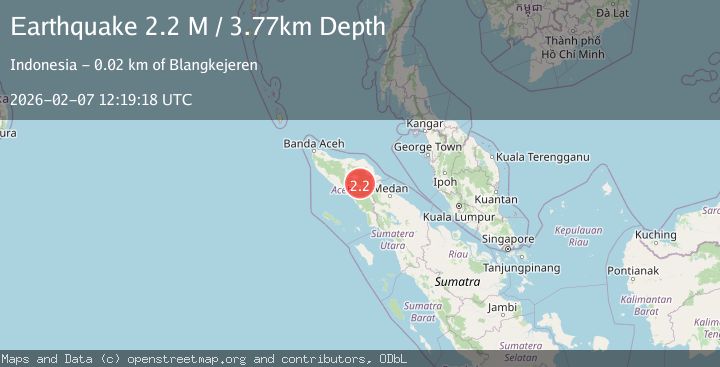
A 2.2 magnitude earthquake struck on Northern Sumatra, Indonesia, at Sat, 07 Feb 2026 12:19:18 GMT. Depth: 3.773035km. Reviewed by BMKG seismologists, this minor quake occurred at a magnitude type of M.
Magnitude
2.2
M
Source
BMKG
Intensity
-
Agency Reports
1 Sources| Source | Magnitude | Depth | Time |
|---|---|---|---|
| BMKGPrimary | 2.2 | 4 km | 1 hour ago |
Earthquake Details
AutomaticEvent IDbmg2026cqoa
Tsunami PotentialNo
Magnitude TypeM
Nearest Places
- Gampong Pinang Rugub1.1 km
- Burni Kacang Minyak2.4 km
- Burni Gentingines2.6 km
- Van Daalen Mountains3.6 km
- Burni Gajah3.8 km
Comments
Join the discussion about this event.
Latest Earthquakes
1.1Mag
25 km W of Minto, Alaska
Time2 minutes ago
Depth13.10 km
SourceUSGS (Automatic)
2.7Mag
HAWAII REGION, HAWAII
Time7 minutes ago
Depth5.10 km
SourceHV (Automatic)
2.3Mag
Flores Sea
Time10 minutes ago
Depth15.55 km
SourceBMKG (Automatic)
1.9Mag
34 km NW of Valdez, Alaska
Time18 minutes ago
Depth27.60 km
SourceUSGS (Automatic)
2.6Mag
POTOSI, BOLIVIA
Time19 minutes ago
Depth225.10 km
SourceCSN (Automatic)
Nearby Earthquakes
3.0Mag
Northern Sumatra, Indonesia
Time6 days ago
Depth5.00 km
SourceBMKG (Automatic)
2.9Mag
Northern Sumatra, Indonesia
Time1 day ago
Depth3.00 km
SourceBMKG (Automatic)
2.2Mag
Northern Sumatra, Indonesia
Time2 weeks ago
Depth2.00 km
SourceBMKG (Automatic)
3.4Mag
Northern Sumatra, Indonesia
Time1 week ago
Depth3.00 km
SourceBMKG (Automatic)
2.3Mag
Northern Sumatra, Indonesia
Time6 days ago
Depth5.00 km
SourceBMKG (Automatic)