Earthquake Sunda Strait, Indonesia
Sat, 07 Feb 2026 23:29:35 GMT
Time1 hour ago
Location
-6.7961, 105.2073
Depth
22.5 KM
Event Summary
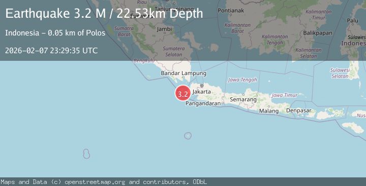
A 3.2 magnitude earthquake struck on Sunda Strait, Indonesia, at Sat, 07 Feb 2026 23:29:35 GMT. Depth: 22.525927km. Reviewed by BMKG seismologists, this minor quake occurred at a magnitude type of M.
Magnitude
3.2
M
Source
BMKG
Intensity
-
Agency Reports
1 Sources| Source | Magnitude | Depth | Time |
|---|---|---|---|
| BMKGPrimary | 3.2 | 23 km | 1 hour ago |
Earthquake Details
AutomaticEvent IDbmg2026crkc
Tsunami PotentialNo
Magnitude TypeM
Nearest Places
- Legon Ramea1.8 km
- Tanjung Cikaret3.3 km
- Tanjung Gede3.6 km
- Legon Pinangkecing3.7 km
- Tanjung Guahpondok3.9 km
Comments
Join the discussion about this event.
Latest Earthquakes
2.6Mag
Java, Indonesia
Time10 minutes ago
Depth19.44 km
SourceBMKG (Automatic)
1.3Mag
7 km S of San Juan Bautista, CA
Time12 minutes ago
Depth7.76 km
SourceUSGS (Automatic)
2.1Mag
Flores Region, Indonesia
Time24 minutes ago
Depth174.47 km
SourceBMKG (Automatic)
1.5Mag
97 km NW of Yakutat, Alaska
Time26 minutes ago
Depth1.80 km
SourceUSGS (Automatic)
2.5Mag
SIKKIM, INDIA
Time28 minutes ago
Depth5.00 km
SourceNDI (Automatic)
Nearby Earthquakes
2.7Mag
Sunda Strait, Indonesia
Time6 days ago
Depth16.71 km
SourceBMKG (Automatic)
2.9Mag
Sunda Strait, Indonesia
Time1 week ago
Depth3.94 km
SourceBMKG (Automatic)
2.7Mag
Sunda Strait, Indonesia
Time1 week ago
Depth0.85 km
SourceBMKG (Automatic)
2.5Mag
SUNDA STRAIT, INDONESIA
Time1 week ago
Depth13.00 km
SourceBMKG (Automatic)
2.5Mag
Sunda Strait, Indonesia
Time1 day ago
Depth2.88 km
SourceBMKG (Automatic)