Earthquake Southern Molucca Sea
Sun, 08 Feb 2026 15:34:15 GMT
Time1 hour ago
Location
-0.4057, 124.2490
Depth
3.0 KM
Event Summary
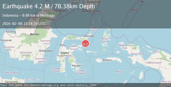
A 4.1 magnitude earthquake struck on Southern Molucca Sea, at Sun, 08 Feb 2026 15:34:15 GMT. Depth: 3.009725km. Reviewed by BMKG seismologists, this light quake occurred at a magnitude type of M.
Magnitude
4.1
M
Source
BMKG
Intensity
-
Agency Reports
1 Sources| Source | Magnitude | Depth | Time |
|---|---|---|---|
| BMKGPrimary | 4.1 | 3 km | 1 hour ago |
Earthquake Details
AutomaticEvent IDbmg2026cspy
Tsunami PotentialNo
Magnitude TypeM
Nearest Places
- Gorontalo Basin32.6 km
- Pulau Molosso64.9 km
- Pulau Pulutiga74.3 km
- Impodnya Tolu87.8 km
- Impoda Panango88.0 km
Comments
Join the discussion about this event.
Latest Earthquakes
1.6Mag
17 km E of Ridgecrest, CA
Time1 hour ago
Depth5.79 km
SourceUSGS (Automatic)
3.3Mag
ANTOFAGASTA, CHILE
Time1 hour ago
Depth125.60 km
SourceCSN (Automatic)
2.0Mag
Sumba Region, Indonesia
Time1 hour ago
Depth14.65 km
SourceBMKG (Automatic)
1.1Mag
NORTHERN ITALY
Time1 hour ago
Depth0.00 km
SourceOGS (Automatic)
1.7Mag
36 km NW of Toyah, Texas
Time1 hour ago
Depth7.83 km
SourceUSGS (Automatic)
Nearby Earthquakes
4.5Mag
Southern Molucca Sea
Time3 days ago
Depth8.83 km
SourceBMKG (Automatic)
2.8Mag
Southern Molucca Sea
Time1 week ago
Depth102.12 km
SourceBMKG (Automatic)
4.3Mag
Southern Molucca Sea
Time2 weeks ago
Depth11.97 km
SourceBMKG (Automatic)
5.1Mag
Southern Molucca Sea
Time1 week ago
Depth10.00 km
SourceBMKG (Automatic)
3.0Mag
Southern Molucca Sea
Time1 week ago
Depth12.21 km
SourceBMKG (Automatic)