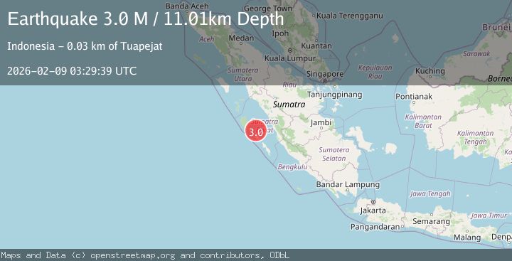
Earthquake Southern Sumatra, Indonesia
Mon, 09 Feb 2026 03:29:39 GMT
Time18 hours ago
Location
-1.7201, 99.6339
Depth
10.0 KM
Event Summary
A 2.7 magnitude earthquake struck on Southern Sumatra, Indonesia, at Mon, 09 Feb 2026 03:29:39 GMT. Depth: 10km. Reviewed by BMKG seismologists, this minor quake occurred at a magnitude type of M.
Magnitude
2.7
M
Source
BMKG
Intensity
-
Agency Reports
1 Sources| Source | Magnitude | Depth | Time |
|---|---|---|---|
| BMKGPrimary | 2.7 | 10 km | 18 hours ago |
Earthquake Details
AutomaticEvent IDbmg2026ctnn
Tsunami PotentialNo
Magnitude TypeM
Nearest Places
- Mentawai Basin28.6 km
- Pulau Siburu29.4 km
- Pulau Silabok31.2 km
- Pulau Taitaiumatsiteut33.3 km
- Pulau Pototoga33.4 km
Comments
Join the discussion about this event.
Latest Earthquakes
3.3Mag
TARAPACA, CHILE
Time18 hours ago
Depth67.30 km
SourceCSN (Automatic)
2.7Mag
ANTOFAGASTA, CHILE
Time19 hours ago
Depth66.10 km
SourceCSN (Automatic)
2.2Mag
Java, Indonesia
Time19 hours ago
Depth30.66 km
SourceBMKG (Automatic)
1.7Mag
37 km E of Schurz, Nevada
Time19 hours ago
Depth7.47 km
SourceUSGS (Automatic)
2.0Mag
10 km SSW of Valencia, CA
Time19 hours ago
Depth9.56 km
SourceUSGS (Automatic)
Nearby Earthquakes
3.3Mag
Southern Sumatra, Indonesia
Time1 day ago
Depth14.52 km
SourceBMKG (Automatic)
2.9Mag
Southern Sumatra, Indonesia
Time3 days ago
Depth17.41 km
SourceBMKG (Automatic)
4.1Mag
KEP. MENTAWAI REGION, INDONESIA
Time2 weeks ago
Depth48.00 km
SourceBMKG (Automatic)
4.5Mag
Southern Sumatra, Indonesia
Time1 week ago
Depth23.34 km
SourceBMKG (Automatic)
3.0Mag
Southern Sumatra, Indonesia
Time2 weeks ago
Depth71.81 km
SourceBMKG (Automatic)