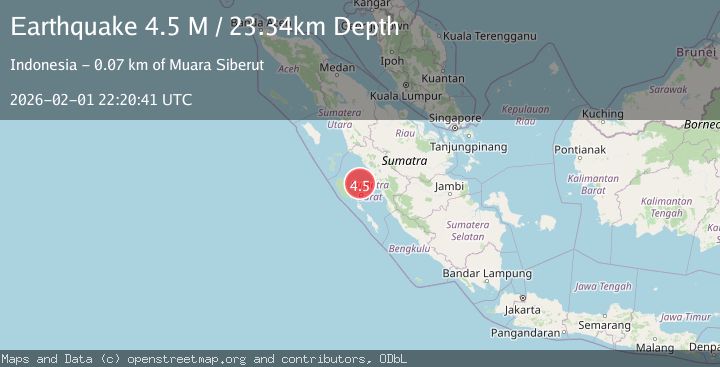
Earthquake Southern Sumatra, Indonesia
Sun, 01 Feb 2026 22:20:42 GMT
Time22 hours ago
Location
-1.1973, 99.6368
Depth
23.6 KM
Event Summary
A 4.3 magnitude earthquake struck on Southern Sumatra, Indonesia, at Sun, 01 Feb 2026 22:20:42 GMT. Depth: 23.628109km. Reviewed by BMKG seismologists, this light quake occurred at a magnitude type of M.
Magnitude
4.3
M
Source
BMKG
Intensity
-
Agency Reports
1 Sources| Source | Magnitude | Depth | Time |
|---|---|---|---|
| BMKGPrimary | 4.3 | 24 km | 22 hours ago |
Earthquake Details
AutomaticEvent IDbmg2026cgiv
Tsunami PotentialNo
Magnitude TypeM
Nearest Places
- Mentawai Basin36.9 km
- Karang Stort50.2 km
- Pulau Laut57.5 km
- Tanjung Bubulu58.8 km
- Pulau Ridai59.3 km
Comments
Join the discussion about this event.
Latest Earthquakes
1.3Mag
22 km WNW of Garden City, Texas
Time22 hours ago
Depth2.90 km
SourceUSGS (Automatic)
1.6Mag
9 km SSE of Girdwood, Alaska
Time22 hours ago
Depth13.90 km
SourceUSGS (Automatic)
1.4Mag
14 km NE of Ridgecrest, CA
Time22 hours ago
Depth8.20 km
SourceUSGS (Automatic)
1.3Mag
20 km N of Indio, CA
Time22 hours ago
Depth4.45 km
SourceUSGS (Automatic)
1.7Mag
56 km N of Karluk, Alaska
Time22 hours ago
Depth74.20 km
SourceUSGS (Automatic)
Nearby Earthquakes
4.1Mag
KEP. MENTAWAI REGION, INDONESIA
Time1 week ago
Depth48.00 km
SourceBMKG (Automatic)
2.8Mag
Southern Sumatra, Indonesia
Time4 days ago
Depth38.19 km
SourceBMKG (Automatic)
4.2Mag
Southern Sumatra, Indonesia
Time1 week ago
Depth56.32 km
SourceBMKG (Automatic)
3.6Mag
Southern Sumatra, Indonesia
Time2 days ago
Depth41.61 km
SourceBMKG (Automatic)
3.0Mag
Southern Sumatra, Indonesia
Time1 week ago
Depth71.81 km
SourceBMKG (Automatic)