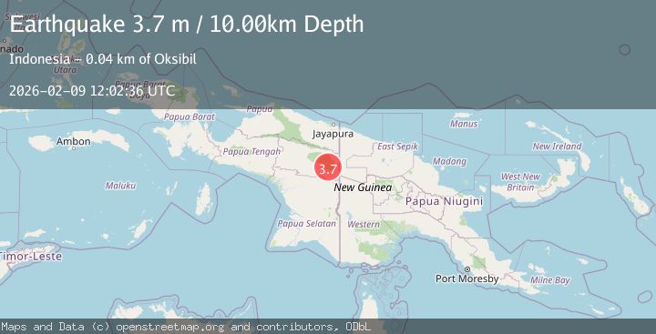
Earthquake West Papua, Indonesia
Mon, 09 Feb 2026 12:02:36 GMT
Time1 hour ago
Location
-4.6045, 140.5906
Depth
10.0 KM
Event Summary
A 3.5 magnitude earthquake struck on West Papua, Indonesia, at Mon, 09 Feb 2026 12:02:36 GMT. Depth: 10km. Reviewed by BMKG seismologists, this minor quake occurred at a magnitude type of M.
Magnitude
3.5
M
Source
BMKG
Intensity
-
Agency Reports
1 Sources| Source | Magnitude | Depth | Time |
|---|---|---|---|
| BMKGPrimary | 3.5 | 10 km | 1 hour ago |
Earthquake Details
AutomaticEvent IDbmg2026cuel
Tsunami PotentialNo
Magnitude TypeM
Nearest Places
- Kampung Iriding3.1 km
- Kampung Atolbol3.3 km
- Kampung Okbifisil5.3 km
- Kampung Okteneng5.8 km
- Kampung Abmisibil7.3 km
Comments
Join the discussion about this event.
Latest Earthquakes
0.5Mag
23 km N of Ridgecrest, CA
Time1 hour ago
Depth5.03 km
SourceUSGS (Automatic)
2.2Mag
FRANCE
Time1 hour ago
Depth5.00 km
SourceReNaSS (Automatic)
2.5Mag
10 km N of Girdwood, Alaska
Time1 hour ago
Depth21.00 km
SourceUSGS (Automatic)
2.3Mag
Sumbawa Region, Indonesia
Time1 hour ago
Depth71.13 km
SourceBMKG (Automatic)
1.9Mag
6 km SW of Volcano, Hawaii
Time1 hour ago
Depth4.95 km
SourceUSGS (Automatic)
Nearby Earthquakes
3.4Mag
West Papua, Indonesia
Time1 week ago
Depth10.00 km
SourceBMKG (Automatic)
2.8Mag
West Papua, Indonesia
Time2 weeks ago
Depth10.00 km
SourceBMKG (Automatic)
4.1Mag
West Papua, Indonesia
Time1 week ago
Depth138.53 km
SourceBMKG (Automatic)
2.6Mag
West Papua, Indonesia
Time2 weeks ago
Depth61.18 km
SourceBMKG (Automatic)
2.8Mag
PAPUA, INDONESIA
Time1 week ago
Depth10.00 km
SourceBMKG (Automatic)