Earthquake South of Bali, Indonesia
Tue, 17 Feb 2026 05:22:27 GMT
Time3 days ago
Location
-9.3041, 114.2284
Depth
32.3 KM
Event Summary
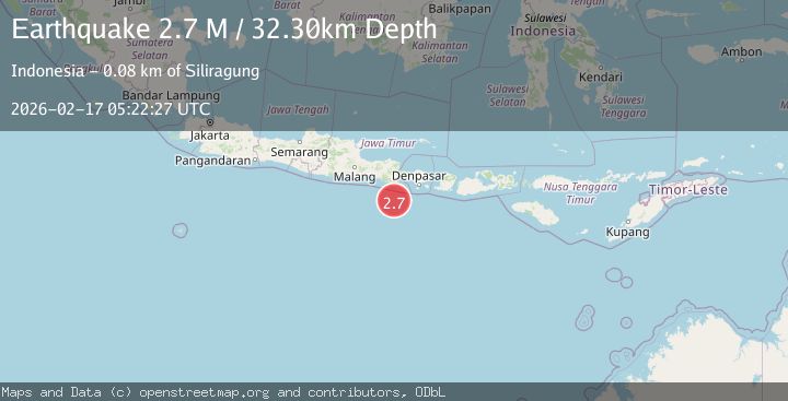
A 2.7 magnitude earthquake struck on South of Bali, Indonesia, at Tue, 17 Feb 2026 05:22:27 GMT. Depth: 32.300919km. Reviewed by BMKG seismologists, this minor quake occurred at a magnitude type of M.
Magnitude
2.7
M
Source
BMKG
Intensity
-
Agency Reports
1 Sources| Source | Magnitude | Depth | Time |
|---|---|---|---|
| BMKGPrimary | 2.7 | 32 km | 3 days ago |
Earthquake Details
ManualEvent IDbmg2026dihh
Tsunami PotentialNo
Magnitude TypeM
Nearest Places
- Kali Bindo59.8 km
- Pulau Batu Mandi61.7 km
- Tanjung Purwo64.2 km
- Crowne Plaza Shenzhen Longgang City Centre64.2 km
- Royal Plaza (Grand)64.4 km
Comments
Join the discussion about this event.
Latest Earthquakes
0.7Mag
7 km WNW of Cobb, CA
Time2 minutes ago
Depth1.75 km
SourceUSGS (Automatic)
1.2Mag
9 km N of Banning, CA
Time4 minutes ago
Depth18.03 km
SourceUSGS (Automatic)
2.1Mag
Southern California
Time5 minutes ago
Depth8.54 km
SourceVYT (Automatic)
2.2Mag
Sweden
Time9 minutes ago
Depth0.00 km
SourceVYT (Automatic)
2.6Mag
West Papua Region, Indonesia
Time12 minutes ago
Depth14.47 km
SourceBMKG
Nearby Earthquakes
2.7Mag
South of Bali, Indonesia
Time0 months ago
Depth21.49 km
SourceBMKG (Automatic)
2.6Mag
SOUTH OF BALI, INDONESIA
Time1 month ago
Depth27.00 km
SourceBMKG (Automatic)
3.0Mag
SOUTH OF BALI, INDONESIA
Time1 month ago
Depth10.00 km
SourceBMKG (Automatic)
2.8Mag
South of Bali, Indonesia
Time3 weeks ago
Depth89.10 km
SourceBMKG (Automatic)
3.0Mag
SOUTH OF BALI, INDONESIA
Time3 years ago
Depth13.00 km
SourceDJA (Automatic)