Earthquake Northern Molucca Sea
Tue, 17 Feb 2026 23:11:01 GMT
Time15 hours ago
Location
1.7337, 126.3284
Depth
17.8 KM
Event Summary
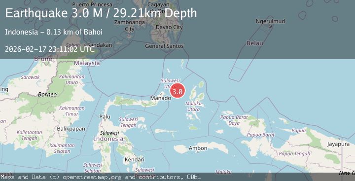
A 3.0 magnitude earthquake struck on Northern Molucca Sea, at Tue, 17 Feb 2026 23:11:01 GMT. Depth: 17.770063km. Reviewed by BMKG seismologists, this minor quake occurred at a magnitude type of M.
Magnitude
3.0
M
Source
BMKG
Intensity
-
Agency Reports
1 Sources| Source | Magnitude | Depth | Time |
|---|---|---|---|
| BMKGPrimary | 3.0 | 18 km | 15 hours ago |
Earthquake Details
ManualEvent IDbmg2026djqn
Tsunami PotentialNo
Magnitude TypeM
Nearest Places
- Kelurahan Mayau44.6 km
- Kelurahan Perum Bersatu45.3 km
- Kelurahan Bido45.7 km
- Pasirputih45.8 km
- Pulau Mayu45.8 km
Comments
Join the discussion about this event.
Latest Earthquakes
1.6Mag
Southern Alaska
Time15 hours ago
Depth20.75 km
SourceVYT (Automatic)
1.8Mag
Southern Alaska
Time15 hours ago
Depth20.02 km
SourceVYT (Automatic)
3.6Mag
DOMINICA REGION, LEEWARD ISLANDS
Time15 hours ago
Depth29.60 km
SourceTRN (Automatic)
1.8Mag
Southern Alaska
Time15 hours ago
Depth16.72 km
SourceVYT (Automatic)
4.3Mag
eastern New Guinea region, Papua New Guinea
Time15 hours ago
Depth81.79 km
SourceVYT (Automatic)
Nearby Earthquakes
3.0Mag
MOLUCCA SEA
Time2 years ago
Depth10.00 km
SourceBMKG (Automatic)
5.0Mag
MOLUCCA SEA
Time9 years ago
Depth60.00 km
SourceEMSC (Automatic)
3.0Mag
MOLUCCA SEA
Time3 months ago
Depth11.00 km
SourceBMKG (Automatic)
4.0Mag
MOLUCCA SEA
Time7 years ago
Depth10.00 km
SourceDJA (Automatic)
3.0Mag
MOLUCCA SEA
Time2 years ago
Depth20.00 km
SourceBMKG (Automatic)