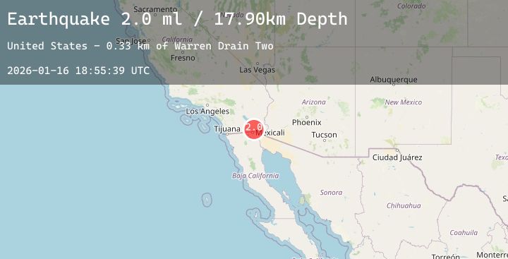
Earthquake SOUTHERN CALIFORNIA
Fri, 16 Jan 2026 18:55:41 GMT
Time2 hours ago
Location
32.7922, -115.4467
Depth
12.2 KM
Event Summary
A 2.0 magnitude earthquake struck on SOUTHERN CALIFORNIA, at Fri, 16 Jan 2026 18:55:41 GMT. Depth: 12.2km. Reviewed by SCSN seismologists, this minor quake occurred at a magnitude type of ml.
Magnitude
2.0
ml
Source
SCSN
Intensity
-
Agency Reports
3 Sources| Source | Magnitude | Depth | Time |
|---|---|---|---|
| SCSNPrimary | 2.0 | 12 km | 2 hours ago |
| USGS | 2.0 | 14 km | 2 hours ago |
| USGS | 1.4 | 8 km | 1 hour ago |
Earthquake Details
AutomaticEvent IDemsc_20260116_0000328
Tsunami PotentialNo
Magnitude Typeml
Nearest Places
- Meloland1.2 km
- Watermans Corner1.2 km
- Meloland Siding1.3 km
- University of California Imperial Valley Fir1.4 km
- Ash Lateral Thirtythree1.5 km
Comments
Join the discussion about this event.
Latest Earthquakes
1.6Mag
8 km E of El Centro, CA
Time38 minutes ago
Depth6.75 km
SourceUSGS (Automatic)
2.6Mag
TARAPACA, CHILE
Time53 minutes ago
Depth115.60 km
SourceCSN (Automatic)
3.0Mag
South of Sumbawa, Indonesia
Time58 minutes ago
Depth10.00 km
SourceBMKG (Automatic)
1.3Mag
5 km SE of Loma Linda, CA
Time59 minutes ago
Depth16.27 km
SourceUSGS (Automatic)
4.1Mag
INDIA-PAKISTAN BORDER REGION
Time1 hour ago
Depth12.00 km
SourceNDI (Automatic)
Nearby Earthquakes
1.6Mag
8 km E of El Centro, CA
Time38 minutes ago
Depth6.75 km
SourceUSGS (Automatic)
2.4Mag
27 km WSW of Westmorland, CA
Time10 hours ago
Depth7.61 km
SourceUSGS (Automatic)
2.1Mag
SOUTHERN CALIFORNIA
Time14 hours ago
Depth9.50 km
SourceSCSN (Automatic)
1.2Mag
26 km WSW of Westmorland, CA
Time18 hours ago
Depth9.33 km
SourceUSGS (Automatic)
1.5Mag
9 km ENE of Heber, CA
Time19 hours ago
Depth13.28 km
SourceUSGS (Automatic)