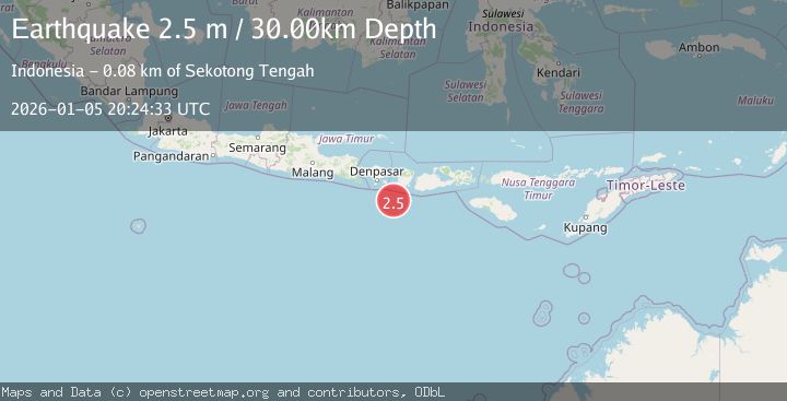
Earthquake SOUTH OF BALI, INDONESIA
Mon, 05 Jan 2026 20:24:33 GMT
Time1 month ago
Location
-9.4800, 115.9000
Depth
30.0 KM
Event Summary
A 2.5 magnitude earthquake struck on SOUTH OF BALI, INDONESIA, at Mon, 05 Jan 2026 20:24:33 GMT. Depth: 30km. Reviewed by BMKG seismologists, this minor quake occurred at a magnitude type of m.
Magnitude
2.5
m
Source
BMKG
Intensity
-
Agency Reports
1 Sources| Source | Magnitude | Depth | Time |
|---|---|---|---|
| BMKGPrimary | 2.5 | 30 km | 1 month ago |
Earthquake Details
AutomaticEvent IDemsc_BMKG_20260105_0000296
Tsunami PotentialNo
Magnitude Typem
Nearest Places
- Lombok Basin40.8 km
- Pulau Sophialouisa62.8 km
- Gili Sarangburung65.5 km
- Tanjung Panggang65.7 km
- Gili Luah66.2 km
Comments
Join the discussion about this event.
Latest Earthquakes
1.0Mag
Southeastern Alaska
Time5 minutes ago
Depth0.00 km
SourceVYT (Automatic)
3.5Mag
COOK STRAIT, NEW ZEALAND
Time6 minutes ago
Depth75.30 km
SourceGNS (Automatic)
2.4Mag
Seram, Indonesia
Time8 minutes ago
Depth18.42 km
SourceBMKG
2.6Mag
West Papua Region, Indonesia
Time11 minutes ago
Depth17.35 km
SourceBMKG
5.0Mag
CENTRAL MID-ATLANTIC RIDGE
Time12 minutes ago
Depth10.00 km
SourceEMSC (Automatic)
Nearby Earthquakes
2.5Mag
SOUTH OF BALI, INDONESIA
Time1 month ago
Depth25.00 km
SourceBMKG (Automatic)
3.0Mag
SOUTH OF BALI, INDONESIA
Time4 years ago
Depth29.00 km
SourceDJA (Automatic)
2.9Mag
South of Bali, Indonesia
Time3 weeks ago
Depth27.22 km
SourceBMKG (Automatic)
2.6Mag
SOUTH OF BALI, INDONESIA
Time1 month ago
Depth10.00 km
SourceBMKG (Automatic)
2.5Mag
SOUTH OF BALI, INDONESIA
Time1 month ago
Depth16.00 km
SourceBMKG (Automatic)