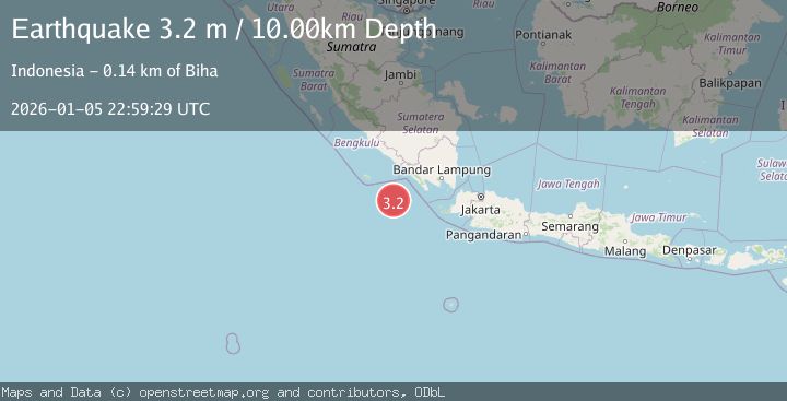
Earthquake SOUTHWEST OF SUMATRA, INDONESIA
Mon, 05 Jan 2026 22:59:29 GMT
Time1 month ago
Location
-6.3500, 103.3500
Depth
10.0 KM
Event Summary
A 3.2 magnitude earthquake struck on SOUTHWEST OF SUMATRA, INDONESIA, at Mon, 05 Jan 2026 22:59:29 GMT. Depth: 10km. Reviewed by BMKG seismologists, this minor quake occurred at a magnitude type of m.
Magnitude
3.2
m
Source
BMKG
Intensity
-
Agency Reports
1 Sources| Source | Magnitude | Depth | Time |
|---|---|---|---|
| BMKGPrimary | 3.2 | 10 km | 1 month ago |
Earthquake Details
AutomaticEvent IDemsc_BMKG_20260105_0000328
Tsunami PotentialNo
Magnitude Typem
Nearest Places
- Enggano Basin58.9 km
- Tanjung Cuku Balimbing127.3 km
- Wai Tembuli130.8 km
- Pulau Betuah131.1 km
- Desa Muara Tembulih131.7 km
Comments
Join the discussion about this event.
Latest Earthquakes
3.7Mag
Papua, Indonesia
Time2 minutes ago
Depth0.00 km
SourceVYT (Automatic)
2.2Mag
Central California
Time4 minutes ago
Depth18.07 km
SourceVYT (Automatic)
2.8Mag
Antofagasta, Chile
Time5 minutes ago
Depth0.00 km
SourceVYT (Automatic)
3.5Mag
MOLUCCA SEA
Time9 minutes ago
Depth184.00 km
SourceBMKG (Automatic)
4.2Mag
North of Halmahera, Indonesia
Time9 minutes ago
Depth129.04 km
SourceBMKG
Nearby Earthquakes
4.0Mag
SOUTHWEST OF SUMATRA, INDONESIA
Time6 years ago
Depth10.00 km
SourceDJA (Automatic)
3.1Mag
SOUTHWEST OF SUMATRA, INDONESIA
Time1 week ago
Depth15.00 km
SourceBMKG (Automatic)
3.0Mag
SOUTHWEST OF SUMATRA, INDONESIA
Time3 years ago
Depth10.00 km
SourceDJA (Automatic)
3.0Mag
SOUTHWEST OF SUMATRA, INDONESIA
Time4 years ago
Depth13.00 km
SourceDJA (Automatic)
2.9Mag
Southwest of Sumatra, Indonesia
Time1 week ago
Depth10.00 km
SourceBMKG (Automatic)