Earthquake SOUTHERN YUKON TERRITORY, CANADA
Wed, 14 Jan 2026 05:57:09 GMT
Time1 month ago
Location
60.5495, -139.8187
Depth
5.0 KM
Event Summary
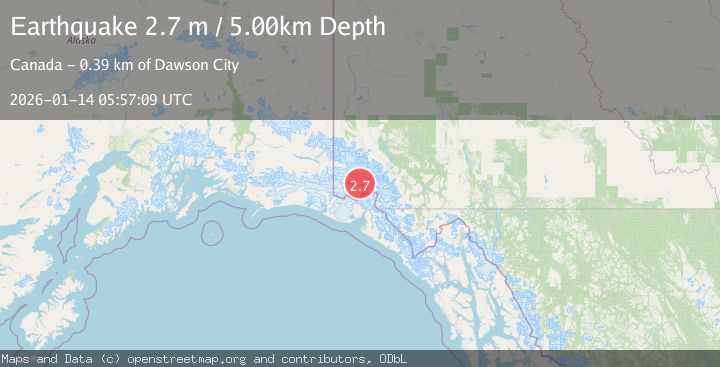
A 2.7 magnitude earthquake struck on SOUTHERN YUKON TERRITORY, CANADA, at Wed, 14 Jan 2026 05:57:09 GMT. Depth: 5km. Reviewed by CN seismologists, this minor quake occurred at a magnitude type of m.
Magnitude
2.7
m
Source
CN
Intensity
-
Agency Reports
1 Sources| Source | Magnitude | Depth | Time |
|---|---|---|---|
| CNPrimary | 2.7 | 5 km | 1 month ago |
Earthquake Details
AutomaticEvent IDemsc_CN_20260114_0000255
Tsunami PotentialNo
Magnitude Typem
Nearest Places
- Mount King George2.7 km
- Marker Lake10.1 km
- Mount Queen Mary10.1 km
- St. Elias Mountains19.0 km
- Mount Vancouver22.2 km
Comments
Join the discussion about this event.
Latest Earthquakes
2.5Mag
northern Sumatra, Indonesia
Time23 hours ago
Depth30.27 km
SourceVYT (Automatic)
1.5Mag
SWITZERLAND
Time23 hours ago
Depth-1.40 km
SourceETHZ (Automatic)
2.3Mag
Poland
Time23 hours ago
Depth6.35 km
SourceVYT (Automatic)
2.3Mag
Halmahera, Indonesia
Time23 hours ago
Depth75.30 km
SourceBMKG
2.5Mag
offshore Valparaiso, Chile
Time23 hours ago
Depth11.47 km
SourceVYT (Automatic)
Nearby Earthquakes
3.2Mag
SOUTHERN YUKON TERRITORY, CANADA
Time1 month ago
Depth5.00 km
SourceNEIC (Automatic)
4.0Mag
SOUTHERN YUKON TERRITORY, CANADA
Time2 months ago
Depth5.00 km
SourceAK (Automatic)
2.7Mag
SOUTHERN YUKON TERRITORY, CANADA
Time1 month ago
Depth5.00 km
SourceNEIC (Automatic)
2.0Mag
Southeastern Alaska
Time6 days ago
Depth27.71 km
SourceVYT (Automatic)
3.3Mag
SOUTHERN YUKON TERRITORY, CANADA
Time1 month ago
Depth9.80 km
SourceNEIC (Automatic)