Earthquake BALI SEA
Mon, 27 Dec 2021 11:53:48 GMT
Time4 years ago
Location
-7.9600, 117.6500
Depth
12.0 KM
Event Summary
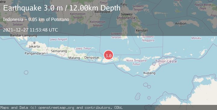
A 3.0 magnitude earthquake struck on BALI SEA, at Mon, 27 Dec 2021 11:53:48 GMT. Depth: 12km. Reviewed by DJA seismologists, this minor quake occurred at a magnitude type of m.
Magnitude
3.0
m
Source
DJA
Intensity
-
Agency Reports
1 Sources| Source | Magnitude | Depth | Time |
|---|---|---|---|
| DJAPrimary | 3.0 | 12 km | 4 years ago |
Earthquake Details
AutomaticEvent IDemsc_DJA_20211227_0000104
Tsunami PotentialNo
Magnitude Typem
Nearest Places
- Satonda Peak19.2 km
- Pulau Satonda19.7 km
- Ndano Satonda20.0 km
- Tanjung Panda21.0 km
- Teluk Patedong21.3 km
Comments
Join the discussion about this event.
Latest Earthquakes
1.7Mag
Southern Alaska
Time17 hours ago
Depth2.44 km
SourceVYT (Automatic)
2.2Mag
Kodiak Island region, Alaska
Time17 hours ago
Depth30.52 km
SourceVYT (Automatic)
1.7Mag
9 km SE of Pearsall, Texas
Time17 hours ago
Depth7.54 km
SourceUSGS (Automatic)
3.9Mag
Flores region, Indonesia
Time18 hours ago
Depth176.39 km
SourceVYT (Automatic)
3.0Mag
near the coast of southern Peru
Time18 hours ago
Depth57.25 km
SourceVYT (Automatic)
Nearby Earthquakes
3.0Mag
BALI SEA
Time4 years ago
Depth10.00 km
SourceDJA (Automatic)
2.1Mag
Bali Sea
Time2 weeks ago
Depth10.00 km
SourceBMKG (Automatic)
2.3Mag
Bali Sea
Time2 weeks ago
Depth10.00 km
SourceBMKG (Automatic)
2.5Mag
BALI SEA
Time1 month ago
Depth24.00 km
SourceBMKG (Automatic)
5.2Mag
BALI SEA
Time13 years ago
Depth40.00 km
SourceEMSC (Automatic)