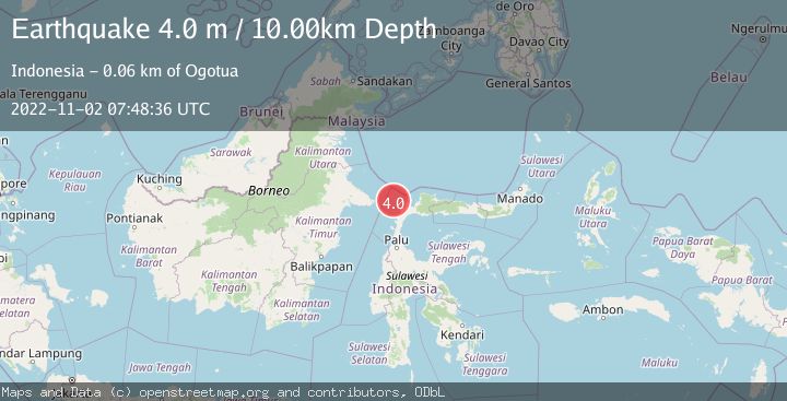
Earthquake MAKASSAR STRAIT, INDONESIA
Wed, 02 Nov 2022 07:48:36 GMT
Time3 years ago
Location
1.0400, 119.7600
Depth
10.0 KM
Event Summary
A 4.0 magnitude earthquake struck on MAKASSAR STRAIT, INDONESIA, at Wed, 02 Nov 2022 07:48:36 GMT. Depth: 10km. Reviewed by DJA seismologists, this light quake occurred at a magnitude type of m.
Magnitude
4.0
m
Source
DJA
Intensity
-
Agency Reports
1 Sources| Source | Magnitude | Depth | Time |
|---|---|---|---|
| DJAPrimary | 4.0 | 10 km | 3 years ago |
Earthquake Details
AutomaticEvent IDemsc_DJA_20221102_0000052
Tsunami PotentialNo
Magnitude Typem
Nearest Places
- Pulau Soyangi47.1 km
- Tando Sojol47.4 km
- Pulau Manukmanuk47.9 km
- Pulau Taring48.1 km
- Tando Baingan48.3 km
Comments
Join the discussion about this event.
Latest Earthquakes
2.8Mag
Fox Islands, Aleutian Islands, Alaska
Time21 hours ago
Depth80.44 km
SourceVYT (Automatic)
0.9Mag
110 km S of McCarthy, Alaska
Time21 hours ago
Depth18.50 km
SourceUSGS (Automatic)
3.0Mag
Central Alaska
Time21 hours ago
Depth0.12 km
SourceVYT (Automatic)
2.5Mag
Minahassa Peninsula, Sulawesi
Time21 hours ago
Depth4.95 km
SourceBMKG
2.9Mag
Minahasa, Sulawesi, Indonesia
Time21 hours ago
Depth10.86 km
SourceVYT (Automatic)
Nearby Earthquakes
3.0Mag
MAKASSAR STRAIT, INDONESIA
Time2 years ago
Depth10.00 km
SourceBMKG (Automatic)
2.5Mag
Minahassa Peninsula, Sulawesi
Time3 weeks ago
Depth40.29 km
SourceBMKG (Automatic)
5.1Mag
MAKASSAR STRAIT, INDONESIA
Time7 years ago
Depth30.00 km
SourceEMSC (Automatic)
5.2Mag
MINAHASA, SULAWESI, INDONESIA
Time5 years ago
Depth10.00 km
SourceEMSC (Automatic)
3.6Mag
Minahassa Peninsula, Sulawesi
Time2 weeks ago
Depth3.49 km
SourceBMKG (Automatic)