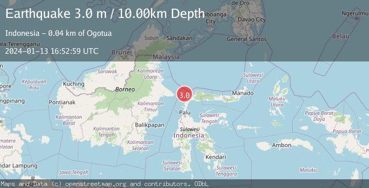
Earthquake MAKASSAR STRAIT, INDONESIA
Sat, 13 Jan 2024 16:52:59 GMT
Time2 years ago
Location
1.0300, 119.8800
Depth
10.0 KM
Event Summary
A 3.0 magnitude earthquake struck on MAKASSAR STRAIT, INDONESIA, at Sat, 13 Jan 2024 16:52:59 GMT. Depth: 10km. Reviewed by BMKG seismologists, this minor quake occurred at a magnitude type of m.
Magnitude
3.0
m
Source
BMKG
Intensity
-
Agency Reports
1 Sources| Source | Magnitude | Depth | Time |
|---|---|---|---|
| BMKGPrimary | 3.0 | 10 km | 2 years ago |
Earthquake Details
AutomaticEvent IDemsc_BMKG_20240113_0000205
Tsunami PotentialNo
Magnitude Typem
Nearest Places
- Pasie Seranga37.4 km
- Pulau Soyangi38.0 km
- Pulau Manukmanuk38.3 km
- Pulau Taring38.4 km
- Pasie Stokan38.5 km
Comments
Join the discussion about this event.
Latest Earthquakes
1.9Mag
Southern California
Time18 hours ago
Depth13.79 km
SourceVYT (Automatic)
1.6Mag
4 km ENE of Cloverdale, CA
Time18 hours ago
Depth2.08 km
SourceUSGS (Automatic)
2.5Mag
Northern Sumatra, Indonesia
Time18 hours ago
Depth28.80 km
SourceBMKG
0.5Mag
Southern Alaska
Time18 hours ago
Depth0.00 km
SourceVYT (Automatic)
3.8Mag
Tarapaca, Chile
Time18 hours ago
Depth93.51 km
SourceVYT (Automatic)
Nearby Earthquakes
5.1Mag
MAKASSAR STRAIT, INDONESIA
Time7 years ago
Depth30.00 km
SourceEMSC (Automatic)
4.0Mag
MAKASSAR STRAIT, INDONESIA
Time3 years ago
Depth10.00 km
SourceDJA (Automatic)
5.2Mag
MINAHASA, SULAWESI, INDONESIA
Time5 years ago
Depth10.00 km
SourceEMSC (Automatic)
2.5Mag
Minahassa Peninsula, Sulawesi
Time3 weeks ago
Depth40.29 km
SourceBMKG (Automatic)
3.6Mag
Minahassa Peninsula, Sulawesi
Time2 weeks ago
Depth3.49 km
SourceBMKG (Automatic)