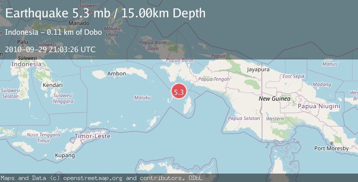
Earthquake NEAR S COAST OF PAPUA, INDONESIA
Wed, 29 Sep 2010 21:03:26 GMT
Time15 years ago
Location
-4.9100, 133.7100
Depth
15.0 KM
Event Summary
A 5.3 magnitude earthquake struck on NEAR S COAST OF PAPUA, INDONESIA, at Wed, 29 Sep 2010 21:03:26 GMT. Depth: 15km. Reviewed by EMSC seismologists, this moderate quake occurred at a magnitude type of mb.
Magnitude
5.3
mb
Source
EMSC
Intensity
-
Agency Reports
1 Sources| Source | Magnitude | Depth | Time |
|---|---|---|---|
| EMSCPrimary | 5.3 | 15 km | 15 years ago |
Earthquake Details
AutomaticEvent IDemsc_EMSC_20100929_0000036
Tsunami PotentialNo
Magnitude Typemb
Nearest Places
- Aru Basin33.6 km
- Pulau Tumbutumbu68.8 km
- Tanjung Watukebo72.6 km
- Labuhan Dabu73.0 km
- Ohoirat73.1 km
Comments
Join the discussion about this event.
Latest Earthquakes
2.6Mag
Java, Indonesia
Time22 hours ago
Depth144.90 km
SourceVYT (Automatic)
3.9Mag
Sunda Strait, Indonesia
Time22 hours ago
Depth97.11 km
SourceBMKG
1.1Mag
6 km N of Running Springs, CA
Time22 hours ago
Depth10.46 km
SourceUSGS (Automatic)
1.7Mag
46 km SSE of Whites City, New Mexico
Time22 hours ago
Depth4.66 km
SourceUSGS (Automatic)
2.2Mag
Halmahera, Indonesia
Time22 hours ago
Depth13.54 km
SourceBMKG
Nearby Earthquakes
6.0Mag
NEAR S COAST OF PAPUA, INDONESIA
Time15 years ago
Depth2.00 km
SourceEMSC (Automatic)
3.7Mag
West Papua Region, Indonesia
Time2 weeks ago
Depth29.83 km
SourceBMKG (Automatic)
5.6Mag
NEAR S COAST OF PAPUA, INDONESIA
Time14 years ago
Depth10.00 km
SourceEMSC (Automatic)
3.3Mag
NEAR S COAST OF PAPUA, INDONESIA
Time1 month ago
Depth10.00 km
SourceBMKG (Automatic)
5.0Mag
NEAR S COAST OF PAPUA, INDONESIA
Time2 years ago
Depth10.00 km
SourceEMSC (Automatic)