Earthquake West Papua Region, Indonesia
Sun, 01 Feb 2026 04:32:59 GMT
Time1 day ago
Location
-4.8752, 133.7740
Depth
29.8 KM
Event Summary
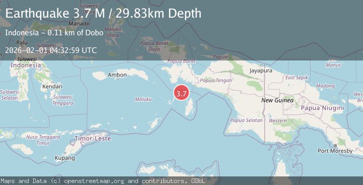
A 3.7 magnitude earthquake struck on West Papua Region, Indonesia, at Sun, 01 Feb 2026 04:32:59 GMT. Depth: 29.826427km. Reviewed by BMKG seismologists, this minor quake occurred at a magnitude type of M.
Magnitude
3.7
M
Source
BMKG
Intensity
-
Agency Reports
1 Sources| Source | Magnitude | Depth | Time |
|---|---|---|---|
| BMKGPrimary | 3.7 | 30 km | 1 day ago |
Earthquake Details
AutomaticEvent IDbmg2026cezp
Tsunami PotentialNo
Magnitude TypeM
Nearest Places
- Aru Basin28.6 km
- Pulau Tumbutumbu67.9 km
- Tanjung Watukebo70.4 km
- Kampung Adi Jaya80.1 km
- Labuhan Dabu81.0 km
Comments
Join the discussion about this event.
Latest Earthquakes
4.2Mag
Sumbawa Region, Indonesia
Time7 hours ago
Depth10.00 km
SourceBMKG (Automatic)
0.7Mag
5 km NNW of The Geysers, CA
Time7 hours ago
Depth1.68 km
SourceUSGS (Automatic)
2.6Mag
Flores Region, Indonesia
Time7 hours ago
Depth8.34 km
SourceBMKG (Automatic)
2.5Mag
Northern Sumatra, Indonesia
Time7 hours ago
Depth198.72 km
SourceBMKG (Automatic)
3.0Mag
COOK STRAIT, NEW ZEALAND
Time7 hours ago
Depth99.80 km
SourceGNS (Automatic)
Nearby Earthquakes
3.8Mag
NEAR S COAST OF PAPUA, INDONESIA
Time1 week ago
Depth54.00 km
SourceBMKG (Automatic)
2.9Mag
West Papua Region, Indonesia
Time1 week ago
Depth10.00 km
SourceBMKG (Automatic)
3.9Mag
West Papua Region, Indonesia
Time21 hours ago
Depth61.54 km
SourceBMKG (Automatic)
3.9Mag
Aru Islands Region, Indonesia
Time1 week ago
Depth32.89 km
SourceBMKG (Automatic)
3.3Mag
PAPUA, INDONESIA
Time2 days ago
Depth10.00 km
SourceBMKG (Automatic)