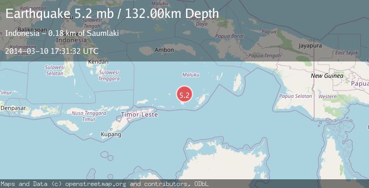
Earthquake KEPULAUAN BABAR, INDONESIA
Mon, 10 Mar 2014 17:31:32 GMT
Time11 years ago
Location
-7.1300, 129.9300
Depth
132.0 KM
Event Summary
A 5.2 magnitude earthquake struck on KEPULAUAN BABAR, INDONESIA, at Mon, 10 Mar 2014 17:31:32 GMT. Depth: 132km. Reviewed by EMSC seismologists, this moderate quake occurred at a magnitude type of mb.
Magnitude
5.2
mb
Source
EMSC
Intensity
-
Agency Reports
1 Sources| Source | Magnitude | Depth | Time |
|---|---|---|---|
| EMSCPrimary | 5.2 | 132 km | 11 years ago |
Earthquake Details
AutomaticEvent IDemsc_EMSC_20140310_0000099
Tsunami PotentialNo
Magnitude Typemb
Nearest Places
- Wakarlawen52.5 km
- Desa Lewah53.5 km
- Lewa53.8 km
- Desa Sinairusi54.1 km
- Desa Hertuti54.7 km
Comments
Join the discussion about this event.
Latest Earthquakes
2.6Mag
Java, Indonesia
Time1 hour ago
Depth9.39 km
SourceBMKG
0.7Mag
3 km NNW of The Geysers, CA
Time1 hour ago
Depth2.60 km
SourceUSGS (Automatic)
1.1Mag
33 km SSE of Glacier View, Alaska
Time1 hour ago
Depth20.20 km
SourceUSGS (Automatic)
1.8Mag
50 km W of Mentone, Texas
Time1 hour ago
Depth3.75 km
SourceUSGS (Automatic)
0.9Mag
81 km NNW of Karluk, Alaska
Time2 hours ago
Depth34.10 km
SourceUSGS (Automatic)
Nearby Earthquakes
3.3Mag
Banda Sea
Time4 days ago
Depth128.66 km
SourceVYT (Automatic)
5.2Mag
KEPULAUAN BABAR, INDONESIA
Time8 years ago
Depth142.00 km
SourceEMSC (Automatic)
5.3Mag
KEPULAUAN BABAR, INDONESIA
Time17 years ago
Depth144.00 km
SourceEMSC (Automatic)
5.3Mag
KEPULAUAN BABAR, INDONESIA
Time1 year ago
Depth105.00 km
SourceEMSC (Automatic)
5.0Mag
KEPULAUAN BABAR, INDONESIA
Time11 years ago
Depth140.00 km
SourceEMSC (Automatic)