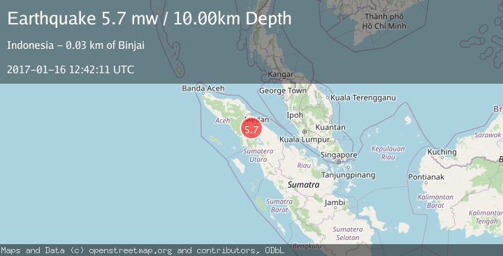
Earthquake NORTHERN SUMATRA, INDONESIA
Mon, 16 Jan 2017 12:42:11 GMT
Time9 years ago
Location
3.4000, 98.3700
Depth
10.0 KM
Event Summary
A 5.7 magnitude earthquake struck on NORTHERN SUMATRA, INDONESIA, at Mon, 16 Jan 2017 12:42:11 GMT. Depth: 10km. Reviewed by EMSC seismologists, this moderate quake occurred at a magnitude type of mw.
Magnitude
5.7
mw
Source
EMSC
Intensity
-
Agency Reports
1 Sources| Source | Magnitude | Depth | Time |
|---|---|---|---|
| EMSCPrimary | 5.7 | 10 km | 9 years ago |
Earthquake Details
AutomaticEvent IDemsc_EMSC_20170116_0000045
Tsunami PotentialNo
Magnitude Typemw
Nearest Places
- Kitematah1.3 km
- Uruk Gedang1.6 km
- Lao Siluman1.8 km
- Lao Bulupring1.9 km
- Kuala Siluman1.9 km
Comments
Join the discussion about this event.
Latest Earthquakes
2.6Mag
West Papua Region, Indonesia
Time3 minutes ago
Depth17.35 km
SourceBMKG
2.8Mag
Antofagasta, Chile
Time7 minutes ago
Depth0.00 km
SourceVYT (Automatic)
3.3Mag
Near North Coast of West Papua
Time8 minutes ago
Depth10.00 km
SourceBMKG
2.5Mag
off the coast of Tarapaca, Chile
Time9 minutes ago
Depth0.00 km
SourceVYT (Automatic)
2.6Mag
Sunda Strait, Indonesia
Time10 minutes ago
Depth8.74 km
SourceBMKG
Nearby Earthquakes
5.0Mag
NORTHERN SUMATRA, INDONESIA
Time9 years ago
Depth10.00 km
SourceEMSC (Automatic)
5.2Mag
NORTHERN SUMATRA, INDONESIA
Time5 years ago
Depth128.00 km
SourceEMSC (Automatic)
3.0Mag
NORTHERN SUMATRA, INDONESIA
Time10 months ago
Depth150.00 km
SourceBMKG (Automatic)
2.6Mag
Northern Sumatra, Indonesia
Time2 weeks ago
Depth105.82 km
SourceBMKG (Automatic)
3.0Mag
NORTHERN SUMATRA, INDONESIA
Time3 years ago
Depth10.00 km
SourceDJA (Automatic)