Earthquake PHILIPPINE ISLANDS REGION
Thu, 12 Aug 2021 21:03:46 GMT
Time4 years ago
Location
6.0700, 127.1200
Depth
67.0 KM
Event Summary
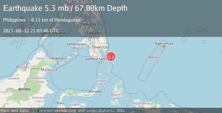
A 5.3 magnitude earthquake struck on PHILIPPINE ISLANDS REGION, at Thu, 12 Aug 2021 21:03:46 GMT. Depth: 67km. Reviewed by EMSC seismologists, this moderate quake occurred at a magnitude type of mb.
Magnitude
5.3
mb
Source
EMSC
Intensity
-
Agency Reports
1 Sources| Source | Magnitude | Depth | Time |
|---|---|---|---|
| EMSCPrimary | 5.3 | 67 km | 4 years ago |
Earthquake Details
AutomaticEvent IDemsc_EMSC_20210812_0000248
Tsunami PotentialNo
Magnitude Typemb
Nearest Places
- Tanjung Dapapa81.2 km
- Desa Pulau Miangas82.3 km
- Pulau Miangas82.3 km
- Kecamatan Miangas82.3 km
- Miangas83.1 km
Comments
Join the discussion about this event.
Latest Earthquakes
2.4Mag
western Texas
Time3 minutes ago
Depth6.10 km
SourceVYT (Automatic)
2.8Mag
Southern Alaska
Time6 minutes ago
Depth14.04 km
SourceVYT (Automatic)
2.4Mag
Southern Alaska
Time8 minutes ago
Depth139.28 km
SourceVYT (Automatic)
1.3Mag
3 km NNE of Moreno Valley, CA
Time9 minutes ago
Depth17.92 km
SourceUSGS (Automatic)
2.5Mag
Minahassa Peninsula, Sulawesi
Time9 minutes ago
Depth139.10 km
SourceBMKG
Nearby Earthquakes
3.0Mag
PHILIPPINE ISLANDS REGION
Time4 years ago
Depth10.00 km
SourcePIVS (Automatic)
5.4Mag
PHILIPPINE ISLANDS REGION
Time4 years ago
Depth26.00 km
SourceEMSC (Automatic)
3.0Mag
PHILIPPINE ISLANDS REGION
Time3 months ago
Depth92.00 km
SourcePIVS (Automatic)
3.0Mag
PHILIPPINE ISLANDS REGION
Time1 year ago
Depth82.00 km
SourcePIVS (Automatic)
3.0Mag
PHILIPPINE ISLANDS REGION
Time1 year ago
Depth79.00 km
SourcePIVS (Automatic)