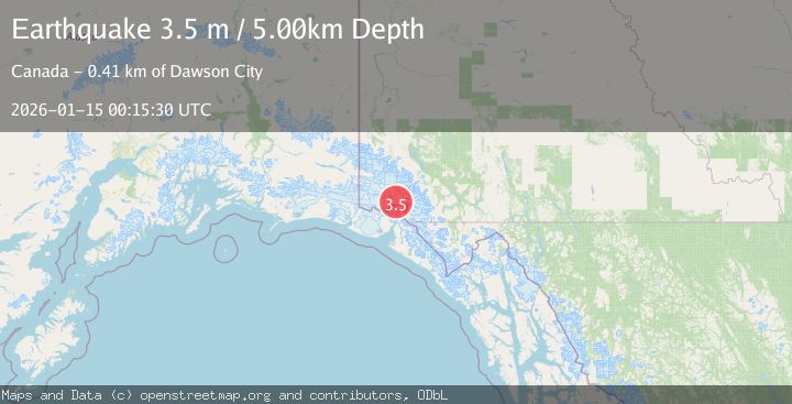
Earthquake SOUTHERN YUKON TERRITORY, CANADA
Thu, 15 Jan 2026 00:15:30 GMT
Time1 month ago
Location
60.4138, -139.4858
Depth
5.0 KM
Event Summary
A 3.5 magnitude earthquake struck on SOUTHERN YUKON TERRITORY, CANADA, at Thu, 15 Jan 2026 00:15:30 GMT. Depth: 5km. Reviewed by NEIC seismologists, this minor quake occurred at a magnitude type of m.
Magnitude
3.5
m
Source
NEIC
Intensity
-
Agency Reports
1 Sources| Source | Magnitude | Depth | Time |
|---|---|---|---|
| NEICPrimary | 3.5 | 5 km | 1 month ago |
Earthquake Details
AutomaticEvent IDemsc_NEIC_20260115_0000075
Tsunami PotentialNo
Magnitude Typem
Nearest Places
- Hubbard Glacier9.8 km
- Hubbard Glacier12.8 km
- Mount Vancouver13.2 km
- St. Elias Mountains15.1 km
- Icefield Ranges20.2 km
Comments
Join the discussion about this event.
Latest Earthquakes
2.7Mag
Near North Coast of West Papua
Time10 minutes ago
Depth45.06 km
SourceBMKG
1.2Mag
Central Alaska
Time11 minutes ago
Depth0.85 km
SourceVYT (Automatic)
2.6Mag
West Papua Region, Indonesia
Time14 minutes ago
Depth10.00 km
SourceBMKG
2.3Mag
WESTERN TURKEY
Time17 minutes ago
Depth10.10 km
SourceKOERI (Automatic)
2.6Mag
Antofagasta, Chile
Time18 minutes ago
Depth0.00 km
SourceVYT (Automatic)
Nearby Earthquakes
3.0Mag
SOUTHERN YUKON TERRITORY, CANADA
Time2 months ago
Depth1.30 km
SourceAK (Automatic)
2.5Mag
SOUTHERN YUKON TERRITORY, CANADA
Time1 week ago
Depth5.00 km
SourceCN (Automatic)
3.7Mag
96 km N of Yakutat, Alaska
Time2 weeks ago
Depth5.00 km
SourceUSGS
3.9Mag
SOUTHERN YUKON TERRITORY, CANADA
Time2 weeks ago
Depth5.00 km
SourceAK (Automatic)
3.0Mag
SOUTHERN YUKON TERRITORY, CANADA
Time2 months ago
Depth5.00 km
SourceNEIC (Automatic)