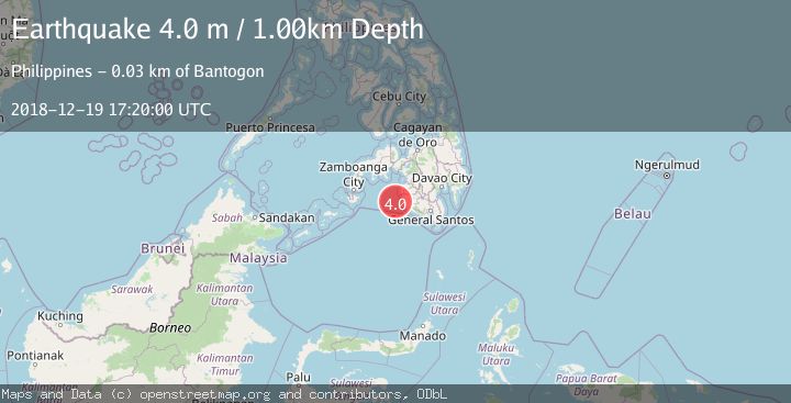
Earthquake MORO GULF, MINDANAO, PHILIPPINES
Wed, 19 Dec 2018 17:20:00 GMT
Time7 years ago
Location
6.4800, 123.7800
Depth
1.0 KM
Event Summary
A 4.0 magnitude earthquake struck on MORO GULF, MINDANAO, PHILIPPINES, at Wed, 19 Dec 2018 17:20:00 GMT. Depth: 1km. Reviewed by PIVS seismologists, this light quake occurred at a magnitude type of m.
Magnitude
4.0
m
Source
PIVS
Intensity
-
Agency Reports
1 Sources| Source | Magnitude | Depth | Time |
|---|---|---|---|
| PIVSPrimary | 4.0 | 1 km | 7 years ago |
Earthquake Details
AutomaticEvent IDemsc_PIVS_20181219_0000098
Tsunami PotentialNo
Magnitude Typem
Nearest Places
- Donaung Shoals23.3 km
- Donauang Island26.9 km
- Nara Point27.2 km
- Point Pitas27.4 km
- Basiauang Bay27.5 km
Comments
Join the discussion about this event.
Latest Earthquakes
2.0Mag
Tarapaca, Chile
Time9 hours ago
Depth104.13 km
SourceVYT (Automatic)
2.0Mag
Tarapaca, Chile
Time9 hours ago
Depth120.97 km
SourceVYT (Automatic)
0.2Mag
8 km W of Cobb, CA
Time9 hours ago
Depth1.64 km
SourceUSGS (Automatic)
4.6Mag
Mindanao, Philippines
Time9 hours ago
Depth62.27 km
SourceBMKG
2.9Mag
offshore Coquimbo, Chile
Time9 hours ago
Depth80.08 km
SourceVYT (Automatic)
Nearby Earthquakes
4.5Mag
Mindanao, Philippines
Time3 weeks ago
Depth170.01 km
SourceBMKG (Automatic)
4.7Mag
MORO GULF, MINDANAO, PHILIPPINES
Time3 weeks ago
Depth35.00 km
SourceEMSC (Automatic)
3.0Mag
MORO GULF, MINDANAO, PHILIPPINES
Time0 months ago
Depth22.00 km
SourcePIVS (Automatic)
4.1Mag
MORO GULF, MINDANAO, PHILIPPINES
Time1 month ago
Depth3.00 km
SourcePIVS (Automatic)
3.8Mag
MORO GULF, MINDANAO, PHILIPPINES
Time2 weeks ago
Depth18.00 km
SourcePIVS (Automatic)