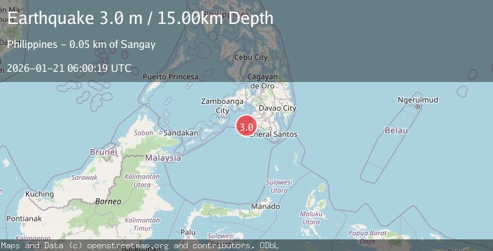
Earthquake MORO GULF, MINDANAO, PHILIPPINES
Wed, 21 Jan 2026 06:00:19 GMT
Time1 month ago
Location
6.3000, 123.6300
Depth
15.0 KM
Event Summary
A 3.0 magnitude earthquake struck on MORO GULF, MINDANAO, PHILIPPINES, at Wed, 21 Jan 2026 06:00:19 GMT. Depth: 15km. Reviewed by PIVS seismologists, this minor quake occurred at a magnitude type of m.
Magnitude
3.0
m
Source
PIVS
Intensity
-
Agency Reports
1 Sources| Source | Magnitude | Depth | Time |
|---|---|---|---|
| PIVSPrimary | 3.0 | 15 km | 1 month ago |
Earthquake Details
AutomaticEvent IDemsc_PIVS_20260121_0000107
Tsunami PotentialNo
Magnitude Typem
Nearest Places
- 46.6 km
- 46.9 km
- 47.0 km
- 47.7 km
- 47.7 km
Comments
Join the discussion about this event.
Latest Earthquakes
2.6Mag
West Papua Region, Indonesia
Time7 minutes ago
Depth21.77 km
SourceBMKG
2.5Mag
Java, Indonesia
Time8 minutes ago
Depth93.36 km
SourceBMKG
2.2Mag
SAN FRANCISCO BAY AREA, CALIF.
Time10 minutes ago
Depth8.50 km
SourceNC (Automatic)
1.6Mag
16 km NW of Parkfield, CA
Time14 minutes ago
Depth3.41 km
SourceUSGS (Automatic)
3.0Mag
West Papua Region, Indonesia
Time17 minutes ago
Depth27.52 km
SourceBMKG
Nearby Earthquakes
3.0Mag
MORO GULF, MINDANAO, PHILIPPINES
Time1 week ago
Depth23.00 km
SourcePIVS (Automatic)
3.9Mag
MORO GULF, MINDANAO, PHILIPPINES
Time1 month ago
Depth10.00 km
SourceNEIC (Automatic)
4.4Mag
Mindanao, Philippines
Time3 weeks ago
Depth10.00 km
SourceBMKG (Automatic)
4.4Mag
MORO GULF, MINDANAO, PHILIPPINES
Time3 weeks ago
Depth10.00 km
SourceNEIC (Automatic)
3.0Mag
MORO GULF, MINDANAO, PHILIPPINES
Time3 weeks ago
Depth16.00 km
SourcePIVS (Automatic)