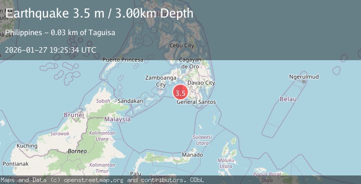
Earthquake MORO GULF, MINDANAO, PHILIPPINES
Tue, 27 Jan 2026 18:25:34 GMT
Time3 hours ago
Location
6.4800, 123.6500
Depth
19.0 KM
Event Summary
A 3.3 magnitude earthquake struck on MORO GULF, MINDANAO, PHILIPPINES, at Tue, 27 Jan 2026 18:25:34 GMT. Depth: 19km. Reviewed by PIVS seismologists, this minor quake occurred at a magnitude type of m.
Magnitude
3.3
m
Source
PIVS
Intensity
-
Agency Reports
1 Sources| Source | Magnitude | Depth | Time |
|---|---|---|---|
| PIVSPrimary | 3.3 | 19 km | 3 hours ago |
Earthquake Details
AutomaticEvent IDemsc_PIVS_20260127_0000342
Tsunami PotentialNo
Magnitude Typem
Nearest Places
- Donaung Shoals37.4 km
- Donauang Island41.2 km
- Nara Point41.4 km
- Point Pitas41.7 km
- Basiauang Bay41.8 km
Comments
Join the discussion about this event.
Latest Earthquakes
0.7Mag
9 km NW of The Geysers, CA
Time3 hours ago
Depth1.51 km
SourceUSGS (Automatic)
2.4Mag
STRAIT OF GIBRALTAR
Time3 hours ago
Depth0.00 km
SourceIGN (Automatic)
2.7Mag
TARAPACA, CHILE
Time3 hours ago
Depth93.10 km
SourceCSN (Automatic)
1.1Mag
54 km SSE of Denali National Park, Alaska
Time3 hours ago
Depth12.30 km
SourceUSGS (Automatic)
2.9Mag
Minahassa Peninsula, Sulawesi
Time4 hours ago
Depth194.17 km
SourceBMKG (Automatic)
Nearby Earthquakes
3.1Mag
MORO GULF, MINDANAO, PHILIPPINES
Time6 days ago
Depth15.00 km
SourcePIVS (Automatic)
3.2Mag
MORO GULF, MINDANAO, PHILIPPINES
Time1 day ago
Depth3.00 km
SourcePIVS (Automatic)
3.3Mag
MORO GULF, MINDANAO, PHILIPPINES
Time6 days ago
Depth23.00 km
SourcePIVS (Automatic)
3.6Mag
MORO GULF, MINDANAO, PHILIPPINES
Time1 day ago
Depth3.00 km
SourcePIVS (Automatic)
3.1Mag
MORO GULF, MINDANAO, PHILIPPINES
Time4 days ago
Depth10.00 km
SourcePIVS (Automatic)