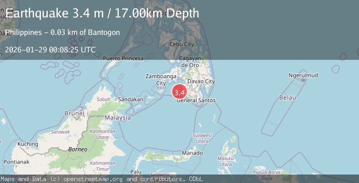
Earthquake MORO GULF, MINDANAO, PHILIPPINES
Wed, 28 Jan 2026 23:16:20 GMT
Time1 hour ago
Location
6.5200, 123.6400
Depth
15.0 KM
Event Summary
A 3.0 magnitude earthquake struck on MORO GULF, MINDANAO, PHILIPPINES, at Wed, 28 Jan 2026 23:16:20 GMT. Depth: 15km. Reviewed by PIVS seismologists, this minor quake occurred at a magnitude type of m.
Magnitude
3.0
m
Source
PIVS
Intensity
-
Agency Reports
1 Sources| Source | Magnitude | Depth | Time |
|---|---|---|---|
| PIVSPrimary | 3.0 | 15 km | 1 hour ago |
Earthquake Details
AutomaticEvent IDemsc_PIVS_20260128_0000416
Tsunami PotentialNo
Magnitude Typem
Nearest Places
- Donaung Shoals38.2 km
- Nara Point42.1 km
- Pidtaguinan Point42.5 km
- Huidobro Reef42.6 km
- Point Pitas42.6 km
Comments
Join the discussion about this event.
Latest Earthquakes
2.0Mag
10 km NNW of Pinnacles, CA
Time1 hour ago
Depth2.80 km
SourceUSGS (Automatic)
2.5Mag
Near North Coast of West Papua
Time1 hour ago
Depth10.00 km
SourceBMKG (Automatic)
0.3Mag
9 km WNW of The Geysers, CA
Time1 hour ago
Depth1.24 km
SourceUSGS (Automatic)
2.7Mag
COQUIMBO, CHILE
Time2 hours ago
Depth90.40 km
SourceCSN (Automatic)
4.3Mag
CHIAPAS, MEXICO
Time2 hours ago
Depth150.30 km
SourceUNM (Automatic)
Nearby Earthquakes
3.5Mag
MORO GULF, MINDANAO, PHILIPPINES
Time1 day ago
Depth19.00 km
SourcePIVS (Automatic)
3.2Mag
MORO GULF, MINDANAO, PHILIPPINES
Time2 days ago
Depth3.00 km
SourcePIVS (Automatic)
3.1Mag
MORO GULF, MINDANAO, PHILIPPINES
Time1 week ago
Depth15.00 km
SourcePIVS (Automatic)
3.0Mag
MORO GULF, MINDANAO, PHILIPPINES
Time6 days ago
Depth6.00 km
SourcePIVS (Automatic)
3.5Mag
MORO GULF, MINDANAO, PHILIPPINES
Time1 day ago
Depth4.00 km
SourcePIVS (Automatic)