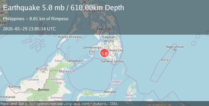
Earthquake MORO GULF, MINDANAO, PHILIPPINES
Thu, 29 Jan 2026 22:31:10 GMT
Time3 hours ago
Location
6.4600, 123.7100
Depth
14.0 KM
Event Summary
A 4.1 magnitude earthquake struck on MORO GULF, MINDANAO, PHILIPPINES, at Thu, 29 Jan 2026 22:31:10 GMT. Depth: 14km. Reviewed by PIVS seismologists, this light quake occurred at a magnitude type of m.
Magnitude
4.1
m
Source
PIVS
Intensity
-
Agency Reports
1 Sources| Source | Magnitude | Depth | Time |
|---|---|---|---|
| PIVSPrimary | 4.1 | 14 km | 3 hours ago |
Earthquake Details
AutomaticEvent IDemsc_PIVS_20260129_0000306
Tsunami PotentialNo
Magnitude Typem
Nearest Places
- Donaung Shoals31.3 km
- Donauang Island34.5 km
- Basiauang Bay35.2 km
- Nara Point35.3 km
- Point Pitas35.4 km
Comments
Join the discussion about this event.
Latest Earthquakes
1.0Mag
7 km NNE of Beaumont, CA
Time3 hours ago
Depth8.31 km
SourceUSGS (Automatic)
3.0Mag
Sumba Region, Indonesia
Time3 hours ago
Depth29.13 km
SourceBMKG (Automatic)
1.4Mag
SWITZERLAND
Time3 hours ago
Depth7.40 km
SourceETHZ (Automatic)
1.6Mag
18 km SW of Mina, Nevada
Time3 hours ago
Depth2.83 km
SourceUSGS (Automatic)
2.1Mag
22 km ENE of Willow, Alaska
Time4 hours ago
Depth41.80 km
SourceUSGS (Automatic)
Nearby Earthquakes
4.8Mag
MORO GULF, MINDANAO, PHILIPPINES
Time1 day ago
Depth8.00 km
SourcePIVS (Automatic)
3.4Mag
MORO GULF, MINDANAO, PHILIPPINES
Time1 week ago
Depth9.00 km
SourcePIVS (Automatic)
3.6Mag
MORO GULF, MINDANAO, PHILIPPINES
Time4 days ago
Depth3.00 km
SourcePIVS (Automatic)
5.4Mag
Mindanao, Philippines
Time2 days ago
Depth16.72 km
SourceBMKG (Automatic)
3.1Mag
MORO GULF, MINDANAO, PHILIPPINES
Time6 days ago
Depth10.00 km
SourcePIVS (Automatic)