Earthquake 93 km WNW of Yakutat, Alaska
Fri, 02 Jan 2026 04:38:07 GMT
Time3 hours ago
Location
59.9420, -141.1870
Depth
4.7 KM
Event Summary
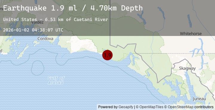
A 1.9 magnitude earthquake struck on 93 km WNW of Yakutat, Alaska, at Fri, 02 Jan 2026 04:38:07 GMT. Depth: 4.7km. Reviewed by USGS seismologists, this minor quake occurred at a magnitude type of ml.
Magnitude
1.9
ml
Source
USGS
Intensity
-
Agency Reports
1 Sources| Source | Magnitude | Depth | Time |
|---|---|---|---|
| USGSPrimary | 1.9 | 5 km | 3 hours ago |
Earthquake Details
AutomaticEvent IDusgs_ak2026aceyow
Tsunami PotentialNo
Magnitude Typeml
Nearest Places
- Caetani River6.5 km
- Lake Caetani7.8 km
- Gull Island9.6 km
- Moraine Island11.2 km
- Moraine Reef13.4 km
Comments
Join the discussion about this event.
Latest Earthquakes
3.2Mag
CENTRAL MEDITERRANEAN SEA
Time19 minutes ago
Depth80.70 km
SourceNOA (Automatic)
0.9Mag
WESTERN TURKEY
Time25 minutes ago
Depth7.00 km
SourceAFAD (Automatic)
3.3Mag
ISLAND OF HAWAII, HAWAII
Time27 minutes ago
Depth30.70 km
SourceHV (Automatic)
2.5Mag
CRETE, GREECE
Time32 minutes ago
Depth31.60 km
SourceNOA (Automatic)
1.4Mag
24 km SSE of Midland, Texas
Time35 minutes ago
Depth4.29 km
SourceUSGS (Automatic)
Nearby Earthquakes
3.7Mag
104 km N of Yakutat, Alaska
Time6 hours ago
Depth10.20 km
SourceUSGS
1.9Mag
80 km NW of Yakutat, Alaska
Time12 hours ago
Depth8.20 km
SourceUSGS (Automatic)
2.7Mag
106 km N of Yakutat, Alaska
Time16 hours ago
Depth5.00 km
SourceUSGS
3.8Mag
SOUTHERN YUKON TERRITORY, CANADA
Time19 hours ago
Depth1.90 km
SourceEMSC (Automatic)
3.8Mag
101 km N of Yakutat, Alaska
Time19 hours ago
Depth1.90 km
SourceUSGS