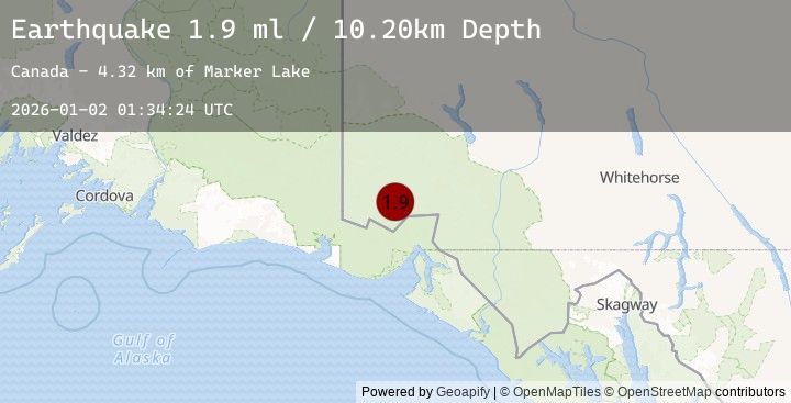
Earthquake 104 km N of Yakutat, Alaska
Fri, 02 Jan 2026 01:34:24 GMT
Time8 hours ago
Location
60.4820, -139.9380
Depth
10.2 KM
Event Summary
A 3.7 magnitude earthquake struck on 104 km N of Yakutat, Alaska, at Fri, 02 Jan 2026 01:34:24 GMT. Depth: 10.2km. Reviewed by USGS seismologists, this minor quake occurred at a magnitude type of ml.
Magnitude
3.7
ml
Source
USGS
Intensity
-
Agency Reports
3 Sources| Source | Magnitude | Depth | Time |
|---|---|---|---|
| USGSPrimary | 1.9 | 10 km | 8 hours ago |
| AK | 3.7 | 12 km | 8 hours ago |
| USGSPrimary | 3.7 | 12 km | 8 hours ago |
Earthquake Details
ConfirmedEvent IDusgs_ak2026abywgc
Tsunami PotentialNo
Magnitude Typeml
Nearest Places
- Marker Lake4.3 km
- Mount King George9.9 km
- Mount Vancouver19.0 km
- Mount Queen Mary20.0 km
- McArthur Peak20.4 km
Comments
Join the discussion about this event.
Latest Earthquakes
3.2Mag
CATAMARCA, ARGENTINA
Time14 minutes ago
Depth146.00 km
SourceNSNA (Automatic)
2.8Mag
CENTRAL TURKEY
Time15 minutes ago
Depth18.50 km
SourceEMSC (Automatic)
2.8Mag
Halmahera, Indonesia
Time17 minutes ago
Depth17.66 km
SourceBMKG (Automatic)
0.7Mag
14 km W of Johannesburg, CA
Time22 minutes ago
Depth5.57 km
SourceUSGS (Automatic)
1.7Mag
NEAR THE COAST OF WESTERN TURKEY
Time27 minutes ago
Depth7.00 km
SourceAFAD (Automatic)
Nearby Earthquakes
3.1Mag
SOUTHERN YUKON TERRITORY, CANADA
Time1 hour ago
Depth5.00 km
SourceNEIC (Automatic)
1.9Mag
93 km WNW of Yakutat, Alaska
Time5 hours ago
Depth4.70 km
SourceUSGS (Automatic)
2.0Mag
98 km N of Yakutat, Alaska
Time9 hours ago
Depth0.00 km
SourceUSGS
1.9Mag
80 km NW of Yakutat, Alaska
Time14 hours ago
Depth8.20 km
SourceUSGS (Automatic)
2.7Mag
106 km N of Yakutat, Alaska
Time18 hours ago
Depth5.00 km
SourceUSGS