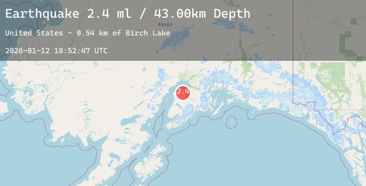
Earthquake 23 km NNE of Sterling, Alaska
Mon, 12 Jan 2026 18:52:47 GMT
Time7 hours ago
Location
60.7180, -150.5290
Depth
43.0 KM
Event Summary
A 2.4 magnitude earthquake struck on 23 km NNE of Sterling, Alaska, at Mon, 12 Jan 2026 18:52:47 GMT. Depth: 43km. Reviewed by USGS seismologists, this minor quake occurred at a magnitude type of ml.
Magnitude
2.4
ml
Source
USGS
Intensity
-
Agency Reports
1 Sources| Source | Magnitude | Depth | Time |
|---|---|---|---|
| USGSPrimary | 2.4 | 43 km | 7 hours ago |
Earthquake Details
AutomaticEvent IDusgs_ak2026avqnvk
Tsunami PotentialNo
Magnitude Typeml
Nearest Places
- Birch Lake0.5 km
- Teal Lake1.0 km
- Portage Lakes1.4 km
- Mallard Lake2.1 km
- Jigsaw Lake2.5 km
Comments
Join the discussion about this event.
Latest Earthquakes
1.5Mag
8 km NW of Pinnacles, CA
Time7 hours ago
Depth7.22 km
SourceUSGS (Automatic)
4.0Mag
Northern Sumatra, Indonesia
Time7 hours ago
Depth5.86 km
SourceBMKG (Automatic)
0.9Mag
6 km NW of The Geysers, CA
Time7 hours ago
Depth2.61 km
SourceUSGS (Automatic)
2.7Mag
Northern Sumatra, Indonesia
Time7 hours ago
Depth14.75 km
SourceBMKG (Automatic)
1.5Mag
36 km NW of Ninilchik, Alaska
Time7 hours ago
Depth87.70 km
SourceUSGS (Automatic)