Earthquake 134 km N of Yakutat, Alaska
Tue, 20 Jan 2026 08:01:19 GMT
Time1 week ago
Location
60.7500, -139.8750
Depth
8.6 KM
Event Summary
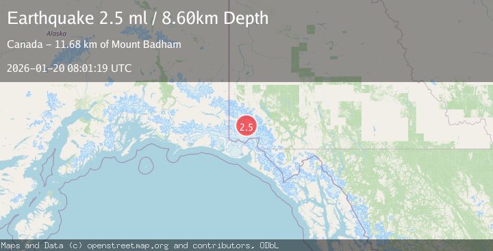
A 2.5 magnitude earthquake struck on 134 km N of Yakutat, Alaska, at Tue, 20 Jan 2026 08:01:19 GMT. Depth: 8.6km. Reviewed by USGS seismologists, this minor quake occurred at a magnitude type of ml.
Magnitude
2.5
ml
Source
USGS
Intensity
-
Agency Reports
1 Sources| Source | Magnitude | Depth | Time |
|---|---|---|---|
| USGSPrimary | 2.5 | 9 km | 1 week ago |
Earthquake Details
ConfirmedEvent IDusgs_ak2026bjmtml
Tsunami PotentialNo
Magnitude Typeml
Nearest Places
- Mount Badham11.7 km
- Donjek Mountain12.2 km
- Mount Queen Mary15.8 km
- Mount Upton17.6 km
- Kluane National Park and Reserve of Canada20.2 km
Comments
Join the discussion about this event.
Latest Earthquakes
2.6Mag
Minahassa Peninsula, Sulawesi
Time13 hours ago
Depth118.00 km
SourceBMKG (Automatic)
2.8Mag
South of Bali, Indonesia
Time13 hours ago
Depth10.00 km
SourceBMKG (Automatic)
1.7Mag
31 km SE of Denali National Park, Alaska
Time14 hours ago
Depth0.60 km
SourceUSGS (Automatic)
2.2Mag
WESTERN TURKEY
Time14 hours ago
Depth14.90 km
SourceKOERI (Automatic)
2.2Mag
13 km NW of Ferry, Alaska
Time14 hours ago
Depth139.50 km
SourceUSGS (Automatic)
Nearby Earthquakes
4.4Mag
SOUTHERN YUKON TERRITORY, CANADA
Time2 days ago
Depth5.00 km
SourceAK (Automatic)
2.5Mag
SOUTHERN YUKON TERRITORY, CANADA
Time17 hours ago
Depth5.90 km
SourceNEIC (Automatic)
0.9Mag
88 km NNW of Yakutat, Alaska
Time3 days ago
Depth36.90 km
SourceUSGS (Automatic)
1.6Mag
102 km NW of Yakutat, Alaska
Time1 day ago
Depth15.10 km
SourceUSGS (Automatic)
1.0Mag
127 km NW of Yakutat, Alaska
Time21 hours ago
Depth19.90 km
SourceUSGS (Automatic)