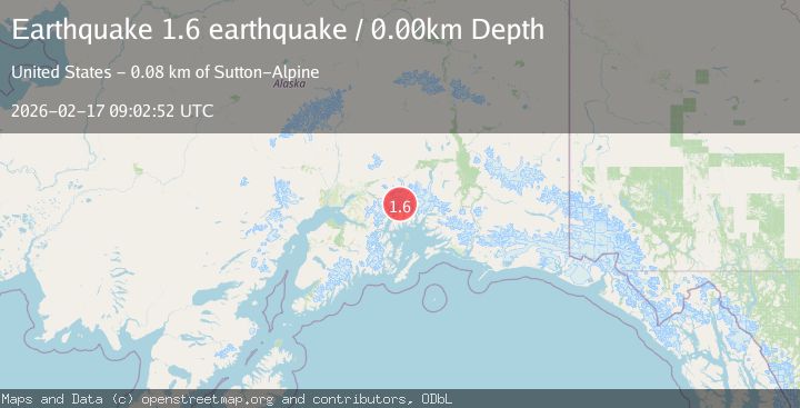
Earthquake 63 km NW of Tatitlek, Alaska
Tue, 17 Feb 2026 09:02:52 GMT
Time1 day ago
Location
61.2200, -147.6070
Depth
6.7 KM
Event Summary
A 1.7 magnitude earthquake struck on 63 km NW of Tatitlek, Alaska, at Tue, 17 Feb 2026 09:02:52 GMT. Depth: 6.7km. Reviewed by USGS seismologists, this minor quake occurred at a magnitude type of ml.
Magnitude
1.7
ml
Source
USGS
Intensity
-
Agency Reports
2 Sources| Source | Magnitude | Depth | Time |
|---|---|---|---|
| USGSPrimary | 1.7 | 7 km | 1 day ago |
| VYT | 1.6 | 0 km | 1 day ago |
Earthquake Details
AutomaticEvent IDusgs_ak2026dizdee
Tsunami PotentialNo
Magnitude Typeml
Nearest Places
- Mount Castner3.6 km
- Ranney Glacier4.7 km
- Yale Glacier5.5 km
- Dartmouth Glacier5.8 km
- Downer Glacier6.0 km
Comments
Join the discussion about this event.
Latest Earthquakes
1.7Mag
2 km NW of The Geysers, CA
Time22 hours ago
Depth0.79 km
SourceUSGS (Automatic)
2.4Mag
Northern Sumatra, Indonesia
Time22 hours ago
Depth3.00 km
SourceBMKG
2.7Mag
SAN JUAN, ARGENTINA
Time23 hours ago
Depth96.00 km
SourceNSNA (Automatic)
3.9Mag
near the north coast of Papua, Indonesia
Time23 hours ago
Depth43.09 km
SourceVYT (Automatic)
2.2Mag
Antofagasta, Chile
Time23 hours ago
Depth125.73 km
SourceVYT (Automatic)
Nearby Earthquakes
1.4Mag
Southern Alaska
Time1 week ago
Depth0.00 km
SourceVYT (Automatic)
1.3Mag
Southern Alaska
Time1 week ago
Depth15.99 km
SourceVYT (Automatic)
5.4Mag
Southern Alaska
Time1 week ago
Depth14.89 km
SourceVYT (Automatic)
2.1Mag
Southern Alaska
Time6 days ago
Depth2.44 km
SourceVYT (Automatic)
0.9Mag
Southern Alaska
Time4 days ago
Depth1.71 km
SourceVYT (Automatic)