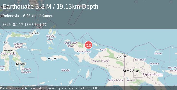
Earthquake near the north coast of Papua, Indonesia
Tue, 17 Feb 2026 13:07:50 GMT
Time18 hours ago
Location
-0.5849, 134.5657
Depth
43.1 KM
Event Summary
A 3.9 magnitude earthquake struck on near the north coast of Papua, Indonesia, at Tue, 17 Feb 2026 13:07:50 GMT. Depth: 43.0908203125km. Reviewed by VYT seismologists, this minor quake occurred at a magnitude type of earthquake.
Magnitude
3.9
earthquake
Source
VYT
Intensity
-
Agency Reports
1 Sources| Source | Magnitude | Depth | Time |
|---|---|---|---|
| VYTPrimary | 3.9 | 43 km | 18 hours ago |
Earthquake Details
AutomaticEvent IDvyt_27g3awcm5xz7
Tsunami PotentialNo
Magnitude Typeearthquake
Nearest Places
- Tanjung Keretsbari48.9 km
- Jenman50.0 km
- Kampung Yenmanu50.1 km
- Kampung Kornasoren50.9 km
- Kampung Asaibori51.3 km
Comments
Join the discussion about this event.
Latest Earthquakes
2.2Mag
Antofagasta, Chile
Time18 hours ago
Depth125.73 km
SourceVYT (Automatic)
2.1Mag
Sumbawa Region, Indonesia
Time18 hours ago
Depth18.83 km
SourceBMKG
2.9Mag
Northern Molucca Sea
Time19 hours ago
Depth10.45 km
SourceBMKG
2.9Mag
South of Java, Indonesia
Time19 hours ago
Depth10.00 km
SourceBMKG
3.2Mag
Potosi, Bolivia
Time19 hours ago
Depth238.53 km
SourceVYT (Automatic)
Nearby Earthquakes
5.1Mag
NEAR N COAST OF PAPUA, INDONESIA
Time16 years ago
Depth40.00 km
SourceEMSC (Automatic)
5.5Mag
NEAR N COAST OF PAPUA, INDONESIA
Time11 years ago
Depth10.00 km
SourceEMSC (Automatic)
2.7Mag
West Papua Region, Indonesia
Time1 week ago
Depth31.14 km
SourceBMKG
4.0Mag
NEAR N COAST OF PAPUA, INDONESIA
Time4 years ago
Depth92.00 km
SourceDJA (Automatic)
2.4Mag
West Papua Region, Indonesia
Time1 week ago
Depth20.30 km
SourceBMKG (Automatic)