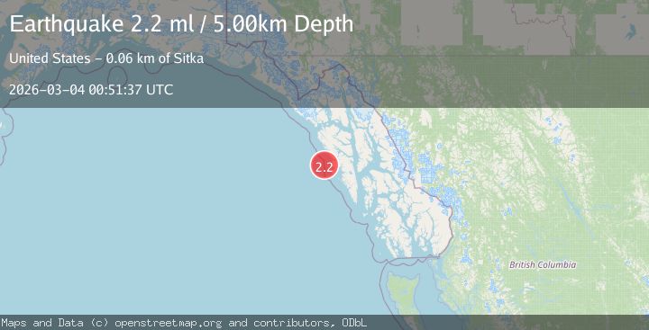
Earthquake 56 km WNW of Sitka, Alaska
Wed, 04 Mar 2026 00:51:37 GMT
Time4 hours ago
Location
57.2170, -136.2070
Depth
5.0 KM
Event Summary
A 2.2 magnitude earthquake struck on 56 km WNW of Sitka, Alaska, at Wed, 04 Mar 2026 00:51:37 GMT. Depth: 5km. Reviewed by USGS seismologists, this minor quake occurred at a magnitude type of ml.
Magnitude
2.2
ml
Source
USGS
Intensity
-
Agency Reports
1 Sources| Source | Magnitude | Depth | Time |
|---|---|---|---|
| USGSPrimary | 2.2 | 5 km | 4 hours ago |
Earthquake Details
AutomaticEvent IDusgs_aka2026ejwsyl
Tsunami PotentialNo
Magnitude Typeml
Nearest Places
- 20.0 km
- 20.8 km
- 21.2 km
- 21.9 km
- 22.3 km
Comments
Join the discussion about this event.
Latest Earthquakes
2.1Mag
offshore Coquimbo, Chile
Time4 hours ago
Depth0.00 km
SourceVYT (Automatic)
2.0Mag
Sumbawa Region, Indonesia
Time4 hours ago
Depth10.00 km
SourceBMKG
1.1Mag
4 km W of Cobb, CA
Time4 hours ago
Depth2.56 km
SourceUSGS (Automatic)
2.2Mag
80 km NE of Koliganek, Alaska
Time4 hours ago
Depth5.00 km
SourceUSGS (Automatic)
3.2Mag
Antofagasta, Chile
Time4 hours ago
Depth70.19 km
SourceVYT (Automatic)
Nearby Earthquakes
2.3Mag
SOUTHEASTERN ALASKA
Time1 month ago
Depth13.40 km
SourceAV (Automatic)
2.2Mag
SOUTHEASTERN ALASKA
Time1 month ago
Depth2.80 km
SourceAV (Automatic)
3.0Mag
SOUTHEASTERN ALASKA
Time6 years ago
Depth5.00 km
SourceNEIR (Automatic)
2.5Mag
19 km WNW of Sitka, Alaska
Time1 month ago
Depth5.50 km
SourceUSGS (Automatic)
1.7Mag
Southeastern Alaska
Time2 weeks ago
Depth198.36 km
SourceVYT (Automatic)