Earthquake 22 km NNE of Karluk, Alaska
Wed, 04 Mar 2026 04:10:45 GMT
Time1 hour ago
Location
57.7570, -154.3260
Depth
27.4 KM
Event Summary
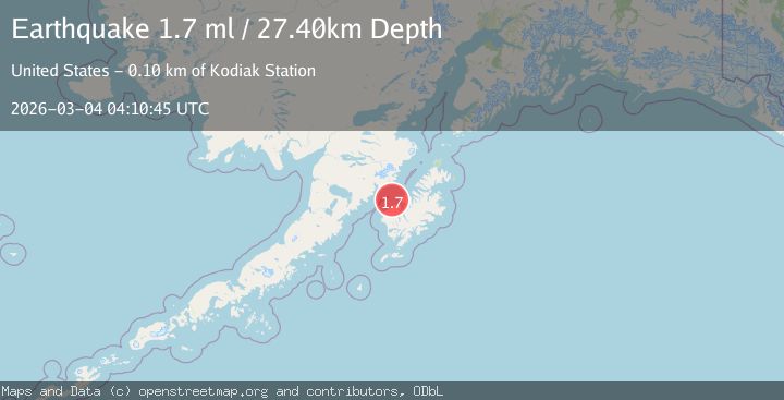
A 1.7 magnitude earthquake struck on 22 km NNE of Karluk, Alaska, at Wed, 04 Mar 2026 04:10:45 GMT. Depth: 27.4km. Reviewed by USGS seismologists, this minor quake occurred at a magnitude type of ml.
Magnitude
1.7
ml
Source
USGS
Intensity
-
Agency Reports
1 Sources| Source | Magnitude | Depth | Time |
|---|---|---|---|
| USGSPrimary | 1.7 | 27 km | 1 hour ago |
Earthquake Details
AutomaticEvent IDusgs_aka2026ekdiqx
Tsunami PotentialNo
Magnitude Typeml
Nearest Places
- 11.8 km
- 12.4 km
- 13.2 km
- 14.5 km
- 15.1 km
Comments
Join the discussion about this event.
Latest Earthquakes
1.0Mag
Southern Alaska
Time1 hour ago
Depth0.00 km
SourceVYT (Automatic)
4.9Mag
Banda Sea
Time1 hour ago
Depth10.00 km
SourceVYT (Automatic)
3.1Mag
OFF E. COAST OF N. ISLAND, N.Z.
Time1 hour ago
Depth277.70 km
SourceGNS (Automatic)
2.3Mag
Northern Sumatra, Indonesia
Time1 hour ago
Depth10.00 km
SourceBMKG
2.0Mag
CENTRAL ITALY
Time1 hour ago
Depth10.10 km
SourceINGV (Automatic)
Nearby Earthquakes
1.7Mag
22 km N of Karluk, Alaska
Time1 month ago
Depth51.40 km
SourceUSGS (Automatic)
3.0Mag
KODIAK ISLAND REGION, ALASKA
Time8 years ago
Depth16.00 km
SourceNEIR (Automatic)
2.1Mag
19 km N of Karluk, Alaska
Time1 month ago
Depth56.00 km
SourceUSGS (Automatic)
2.7Mag
Kodiak Island region, Alaska
Time1 week ago
Depth16.60 km
SourceVYT (Automatic)
3.0Mag
KODIAK ISLAND REGION, ALASKA
Time2 years ago
Depth42.50 km
SourceAK (Automatic)