Earthquake 15 km N of Warner Springs, CA
Fri, 16 Jan 2026 14:13:01 GMT
Time4 hours ago
Location
33.4195, -116.6138
Depth
4.7 KM
Event Summary
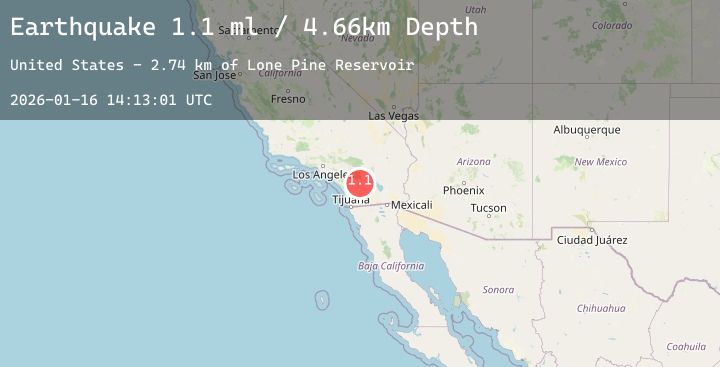
A 2.2 magnitude earthquake struck on 15 km N of Warner Springs, CA, at Fri, 16 Jan 2026 14:13:01 GMT. Depth: 4.65999984741211km. Reviewed by USGS seismologists, this minor quake occurred at a magnitude type of ml.
Magnitude
2.2
ml
Source
USGS
Intensity
-
Agency Reports
3 Sources| Source | Magnitude | Depth | Time |
|---|---|---|---|
| USGSPrimary | 1.1 | 5 km | 4 hours ago |
| SCSN | 2.2 | 9 km | 3 hours ago |
| USGSPrimary | 2.2 | 9 km | 3 hours ago |
Earthquake Details
AutomaticEvent IDusgs_ci41159631
Tsunami PotentialNo
Magnitude Typeml
Nearest Places
- Lone Pine Reservoir2.7 km
- Combs Peak2.9 km
- Bucksnort Mountain3.4 km
- Tule Spring4.7 km
- Twin Lakes4.9 km
Comments
Join the discussion about this event.
Latest Earthquakes
1.9Mag
13 km NNE of Tres Pinos, CA
Time4 minutes ago
Depth6.19 km
SourceUSGS (Automatic)
2.4Mag
Sumbawa Region, Indonesia
Time9 minutes ago
Depth17.58 km
SourceBMKG (Automatic)
3.1Mag
Minahassa Peninsula, Sulawesi
Time10 minutes ago
Depth125.41 km
SourceBMKG (Automatic)
1.2Mag
10 km E of Murrieta Hot Springs, CA
Time15 minutes ago
Depth12.42 km
SourceUSGS (Automatic)
1.4Mag
12 km W of Stanton, Texas
Time16 minutes ago
Depth8.18 km
SourceUSGS (Automatic)
Nearby Earthquakes
1.2Mag
10 km E of Murrieta Hot Springs, CA
Time15 minutes ago
Depth12.42 km
SourceUSGS (Automatic)
1.4Mag
12 km ENE of Desert Hot Springs, CA
Time2 hours ago
Depth5.81 km
SourceUSGS (Automatic)
2.4Mag
27 km WSW of Westmorland, CA
Time7 hours ago
Depth7.61 km
SourceUSGS (Automatic)
0.7Mag
4 km NNW of San Jacinto, CA
Time8 hours ago
Depth14.61 km
SourceUSGS (Automatic)
1.4Mag
21 km ESE of Anza, CA
Time10 hours ago
Depth4.45 km
SourceUSGS (Automatic)