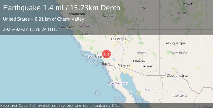
Earthquake 12 km E of Yucaipa, CA
Sun, 22 Feb 2026 11:26:24 GMT
Time1 hour ago
Location
34.0405, -116.9165
Depth
15.7 KM
Event Summary
A 1.4 magnitude earthquake struck on 12 km E of Yucaipa, CA, at Sun, 22 Feb 2026 11:26:24 GMT. Depth: 15.7299995422363km. Reviewed by USGS seismologists, this minor quake occurred at a magnitude type of ml.
Magnitude
1.4
ml
Source
USGS
Intensity
-
Agency Reports
1 Sources| Source | Magnitude | Depth | Time |
|---|---|---|---|
| USGSPrimary | 1.4 | 16 km | 1 hour ago |
Earthquake Details
AutomaticEvent IDusgs_ci41401504
Tsunami PotentialNo
Magnitude Typeml
Nearest Places
- 0.9 km
- 1.1 km
- 1.2 km
- 1.2 km
- 1.7 km
Comments
Join the discussion about this event.
Latest Earthquakes
2.9Mag
Central Alaska
Time1 hour ago
Depth109.62 km
SourceVYT (Automatic)
2.4Mag
Java, Indonesia
Time1 hour ago
Depth96.29 km
SourceBMKG
2.5Mag
Southern Alaska
Time1 hour ago
Depth126.22 km
SourceVYT (Automatic)
1.5Mag
31 km WSW of Anchor Point, Alaska
Time1 hour ago
Depth76.50 km
SourceUSGS (Automatic)
1.2Mag
western Texas
Time1 hour ago
Depth1.34 km
SourceVYT (Automatic)
Nearby Earthquakes
3.0Mag
SOUTHERN CALIFORNIA
Time2 years ago
Depth5.00 km
SourceNEIC (Automatic)
1.2Mag
9 km N of Banning, CA
Time2 days ago
Depth18.03 km
SourceUSGS (Automatic)
1.1Mag
12 km N of Banning, CA
Time2 weeks ago
Depth12.38 km
SourceUSGS (Automatic)
2.2Mag
Southern California
Time1 week ago
Depth16.97 km
SourceVYT (Automatic)
3.0Mag
SOUTHERN CALIFORNIA
Time11 years ago
Depth16.00 km
SourceNEIR (Automatic)