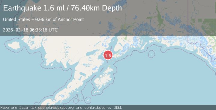
Earthquake Southern Alaska
Wed, 18 Feb 2026 06:33:15 GMT
Time1 hour ago
Location
59.3605, -152.5212
Depth
75.6 KM
Event Summary
A 1.6 magnitude earthquake struck on Southern Alaska, at Wed, 18 Feb 2026 06:33:15 GMT. Depth: 75.5615234375km. Reviewed by VYT seismologists, this minor quake occurred at a magnitude type of earthquake.
Magnitude
1.6
earthquake
Source
VYT
Intensity
-
Agency Reports
2 Sources| Source | Magnitude | Depth | Time |
|---|---|---|---|
| VYTPrimary | 1.3 | 76 km | 1 hour ago |
| USGS | 1.6 | 76 km | 1 hour ago |
Earthquake Details
AutomaticEvent IDvyt_1wzao4ciw41js
Tsunami PotentialNo
Magnitude Typeearthquake
Nearest Places
- Jakolof Bay11.8 km
- Cook Inlet27.1 km
- Magnet Rock29.8 km
- Flat Island Light30.0 km
- Flat Islands30.1 km
Comments
Join the discussion about this event.
Latest Earthquakes
1.0Mag
8 km NW of The Geysers, CA
Time1 hour ago
Depth1.53 km
SourceUSGS (Automatic)
2.7Mag
Java, Indonesia
Time1 hour ago
Depth40.72 km
SourceBMKG
1.7Mag
Central Alaska
Time1 hour ago
Depth0.00 km
SourceVYT (Automatic)
3.1Mag
south of Alaska
Time1 hour ago
Depth10.00 km
SourceVYT (Automatic)
2.0Mag
Finland-Russia border region
Time1 hour ago
Depth256.59 km
SourceVYT (Automatic)
Nearby Earthquakes
3.0Mag
SOUTHERN ALASKA
Time7 years ago
Depth66.00 km
SourceNEIR (Automatic)
2.3Mag
Southern Alaska
Time1 day ago
Depth205.20 km
SourceVYT (Automatic)
3.0Mag
SOUTHERN ALASKA
Time8 years ago
Depth64.00 km
SourceNEIR (Automatic)
2.3Mag
SOUTHERN ALASKA
Time1 month ago
Depth69.40 km
SourceNEIC (Automatic)
2.1Mag
47 km W of Nanwalek, Alaska
Time1 week ago
Depth85.40 km
SourceUSGS (Automatic)