Earthquake north of Halmahera, Indonesia
Fri, 13 Feb 2026 20:27:48 GMT
Time4 days ago
Location
4.3478, 128.4103
Depth
10.0 KM
Event Summary
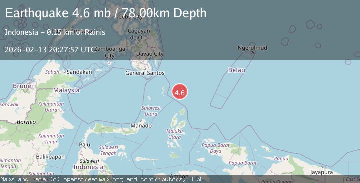
A 5.1 magnitude earthquake struck on north of Halmahera, Indonesia, at Fri, 13 Feb 2026 20:27:48 GMT. Depth: 10km. Reviewed by VYT seismologists, this moderate quake occurred at a magnitude type of earthquake.
Magnitude
5.1
earthquake
Source
VYT
Intensity
-
Agency Reports
5 Sources| Source | Magnitude | Depth | Time |
|---|---|---|---|
| VYTPrimary | 4.7 | 10 km | 4 days ago |
| BMKG | 5.1 | 17 km | 4 days ago |
| NEIC | 4.6 | 80 km | 4 days ago |
| USGS | 4.6 | 80 km | 4 days ago |
| EMSC | 4.6 | 78 km | 4 days ago |
Earthquake Details
AutomaticEvent IDvyt_21cna7884d48k
Tsunami PotentialNo
Magnitude Typeearthquake
Nearest Places
- Snellius Ridge59.7 km
- Talaud Trough116.8 km
- Pulau Kakorotan142.1 km
- Desa Kakorotan142.1 km
- Pulau Intata142.6 km
Comments
Join the discussion about this event.
Latest Earthquakes
1.1Mag
Valparaiso, Chile
Time16 hours ago
Depth42.24 km
SourceVYT (Automatic)
1.7Mag
48 km W of Mentone, Texas
Time16 hours ago
Depth5.91 km
SourceUSGS (Automatic)
2.3Mag
offshore Atacama, Chile
Time16 hours ago
Depth0.24 km
SourceVYT (Automatic)
3.1Mag
Sulawesi, Indonesia
Time16 hours ago
Depth0.00 km
SourceVYT (Automatic)
2.4Mag
western Texas
Time16 hours ago
Depth4.15 km
SourceVYT (Automatic)
Nearby Earthquakes
5.7Mag
north of Halmahera, Indonesia
Time5 days ago
Depth10.00 km
SourceVYT (Automatic)
3.9Mag
North of Halmahera, Indonesia
Time5 days ago
Depth10.00 km
SourceBMKG
5.0Mag
North of Halmahera, Indonesia
Time4 days ago
Depth10.00 km
SourceBMKG
4.4Mag
North of Halmahera, Indonesia
Time4 days ago
Depth10.00 km
SourceBMKG
3.9Mag
North of Halmahera, Indonesia
Time4 days ago
Depth91.68 km
SourceBMKG