Earthquake Southern Alaska
Thu, 12 Feb 2026 17:57:08 GMT
Time6 days ago
Location
61.6056, -146.6430
Depth
3.9 KM
Event Summary
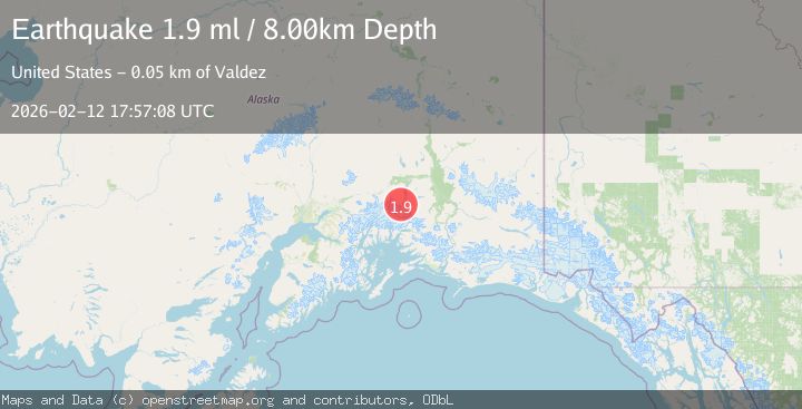
A 2.0 magnitude earthquake struck on Southern Alaska, at Thu, 12 Feb 2026 17:57:08 GMT. Depth: 3.90625km. Reviewed by VYT seismologists, this minor quake occurred at a magnitude type of earthquake.
Magnitude
2.0
earthquake
Source
VYT
Intensity
-
Agency Reports
2 Sources| Source | Magnitude | Depth | Time |
|---|---|---|---|
| VYTPrimary | 2.0 | 4 km | 6 days ago |
| USGS | 1.9 | 8 km | 6 days ago |
Earthquake Details
AutomaticEvent IDvyt_2c55my70928hr
Tsunami PotentialNo
Magnitude Typeearthquake
Nearest Places
- Iceberg Lake9.0 km
- Tazlina Glacier13.4 km
- Nelchina Glacier15.9 km
- Brontosaurus Mountain16.2 km
- Klanelneechena Creek16.5 km
Comments
Join the discussion about this event.
Latest Earthquakes
2.2Mag
Seram, Indonesia
Time2 minutes ago
Depth11.12 km
SourceBMKG
2.6Mag
West Papua Region, Indonesia
Time5 minutes ago
Depth17.35 km
SourceBMKG
2.8Mag
Antofagasta, Chile
Time9 minutes ago
Depth0.00 km
SourceVYT (Automatic)
3.3Mag
Near North Coast of West Papua
Time10 minutes ago
Depth10.00 km
SourceBMKG
2.5Mag
off the coast of Tarapaca, Chile
Time11 minutes ago
Depth0.00 km
SourceVYT (Automatic)
Nearby Earthquakes
2.0Mag
Southern Alaska
Time23 hours ago
Depth0.00 km
SourceVYT (Automatic)
3.0Mag
SOUTHERN ALASKA
Time11 months ago
Depth31.30 km
SourceAK (Automatic)
3.0Mag
SOUTHERN ALASKA
Time3 years ago
Depth32.00 km
SourceNEIC (Automatic)
1.9Mag
48 km SSE of Nelchina, Alaska
Time1 week ago
Depth22.00 km
SourceUSGS (Automatic)
2.9Mag
SOUTHERN ALASKA
Time2 weeks ago
Depth21.80 km
SourceAK (Automatic)