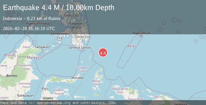
Earthquake north of Halmahera, Indonesia
Fri, 20 Feb 2026 16:36:32 GMT
Time1 hour ago
Location
4.1130, 128.1555
Depth
10.0 KM
Event Summary
A 3.5 magnitude earthquake struck on north of Halmahera, Indonesia, at Fri, 20 Feb 2026 16:36:32 GMT. Depth: 10km. Reviewed by VYT seismologists, this minor quake occurred at a magnitude type of earthquake.
Magnitude
3.5
earthquake
Source
VYT
Intensity
-
Agency Reports
1 Sources| Source | Magnitude | Depth | Time |
|---|---|---|---|
| VYTPrimary | 3.5 | 10 km | 1 hour ago |
Earthquake Details
AutomaticEvent IDvyt_2txru8klpdqol
Tsunami PotentialNo
Magnitude Typeearthquake
Nearest Places
- Snellius Ridge21.3 km
- Talaud Trough82.9 km
- Pulau Karis116.0 km
- Pulau Kakorotan124.3 km
- Desa Kakorotan124.3 km
Comments
Join the discussion about this event.
Latest Earthquakes
3.1Mag
Sulawesi, Indonesia
Time1 hour ago
Depth0.00 km
SourceVYT (Automatic)
1.9Mag
Southeastern Alaska
Time1 hour ago
Depth17.82 km
SourceVYT (Automatic)
2.5Mag
Seram, Indonesia
Time1 hour ago
Depth8.80 km
SourceBMKG
2.8Mag
Potosi, Bolivia
Time1 hour ago
Depth189.82 km
SourceVYT (Automatic)
1.6Mag
PYRENEES
Time1 hour ago
Depth0.00 km
SourceIGN (Automatic)
Nearby Earthquakes
6.0Mag
NORTH OF HALMAHERA, INDONESIA
Time4 years ago
Depth160.00 km
SourceEMSC (Automatic)
5.0Mag
NORTH OF HALMAHERA, INDONESIA
Time12 years ago
Depth70.00 km
SourceEMSC (Automatic)
3.9Mag
North of Halmahera, Indonesia
Time5 days ago
Depth9.91 km
SourceBMKG
4.9Mag
north of Halmahera, Indonesia
Time5 days ago
Depth10.00 km
SourceVYT (Automatic)
4.5Mag
north of Halmahera, Indonesia
Time5 days ago
Depth10.00 km
SourceVYT (Automatic)