Earthquake Timor region, Indonesia
Thu, 12 Feb 2026 00:51:19 GMT
Time1 week ago
Location
-8.6292, 124.3689
Depth
312.1 KM
Event Summary
A 3.4 magnitude earthquake struck on Timor region, Indonesia, at Thu, 12 Feb 2026 00:51:19 GMT. Depth: 312.1337890625km. Reviewed by VYT seismologists, this minor quake occurred at a magnitude type of earthquake.
Magnitude
3.4
earthquake
Source
VYT
Intensity
-
Agency Reports
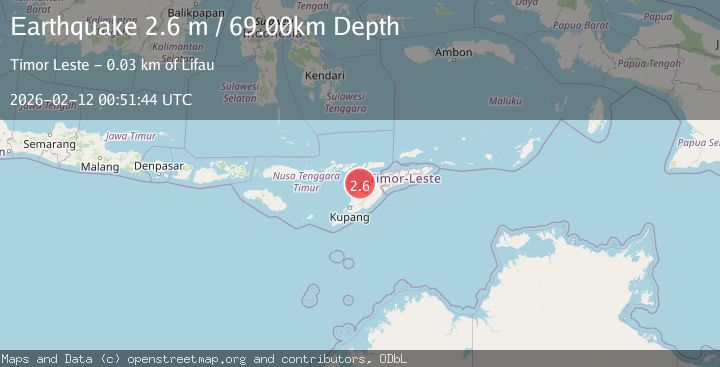
2 Sources| Source | Magnitude | Depth | Time |
|---|---|---|---|
| VYTPrimary | 3.4 | 312 km | 1 week ago |
| BMKG | 2.6 | 69 km | 1 week ago |
Earthquake Details
AutomaticEvent IDvyt_362bepqpqzjq8
Tsunami PotentialNo
Magnitude Typeearthquake
Nearest Places
- Tanjung Gemuk18.4 km
- Tanjung Keltetek18.4 km
- Tanjung Parilal18.4 km
- Teluk Tebakomi18.6 km
- Tuabira18.9 km
Comments
Join the discussion about this event.
Latest Earthquakes
2.7Mag
Antofagasta, Chile
Time2 minutes ago
Depth77.88 km
SourceVYT (Automatic)
2.0Mag
Mendoza, Argentina
Time4 minutes ago
Depth7.20 km
SourceVYT (Automatic)
4.2Mag
Kepulauan Talaud, Indonesia
Time11 minutes ago
Depth85.57 km
SourceVYT (Automatic)
2.1Mag
STRAIT OF GIBRALTAR
Time11 minutes ago
Depth1.30 km
SourceIGN (Automatic)
2.0Mag
Antofagasta, Chile
Time14 minutes ago
Depth127.32 km
SourceVYT (Automatic)
Nearby Earthquakes
3.0Mag
KEPULAUAN ALOR, INDONESIA
Time3 years ago
Depth18.00 km
SourceDJA (Automatic)
2.3Mag
Timor Region
Time4 days ago
Depth0.87 km
SourceBMKG
2.1Mag
Timor Region
Time1 week ago
Depth94.29 km
SourceBMKG (Automatic)
3.0Mag
KEPULAUAN ALOR, INDONESIA
Time4 years ago
Depth85.00 km
SourceDJA (Automatic)
2.7Mag
Timor Region
Time1 week ago
Depth95.97 km
SourceBMKG (Automatic)