Earthquake Southern Alaska
Fri, 13 Feb 2026 14:27:10 GMT
Time4 days ago
Location
59.1203, -154.0474
Depth
107.8 KM
Event Summary
A 2.4 magnitude earthquake struck on Southern Alaska, at Fri, 13 Feb 2026 14:27:10 GMT. Depth: 107.7880859375km. Reviewed by VYT seismologists, this minor quake occurred at a magnitude type of earthquake.
Magnitude
2.4
earthquake
Source
VYT
Intensity
-
Agency Reports
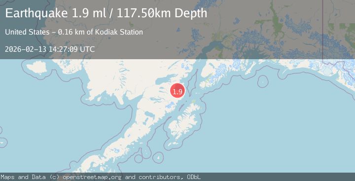
2 Sources| Source | Magnitude | Depth | Time |
|---|---|---|---|
| VYTPrimary | 2.4 | 108 km | 4 days ago |
| USGS | 1.9 | 118 km | 4 days ago |
Earthquake Details
AutomaticEvent IDvyt_imoeonj3fwjn
Tsunami PotentialNo
Magnitude Typeearthquake
Nearest Places
- McNeil Islet6.3 km
- Nordyke Islands6.8 km
- Nordyke Island7.0 km
- McNeil Head7.3 km
- Horseshoe Cove7.8 km
Comments
Join the discussion about this event.
Latest Earthquakes
1.4Mag
Kenai Peninsula, Alaska
Time14 hours ago
Depth35.28 km
SourceVYT (Automatic)
1.1Mag
87 km N of Karluk, Alaska
Time14 hours ago
Depth5.00 km
SourceUSGS (Automatic)
2.3Mag
Southern Sumatra, Indonesia
Time14 hours ago
Depth36.72 km
SourceBMKG
2.6Mag
Java, Indonesia
Time14 hours ago
Depth62.13 km
SourceBMKG
1.8Mag
Tarapaca, Chile
Time14 hours ago
Depth0.00 km
SourceVYT (Automatic)
Nearby Earthquakes
1.5Mag
Southern Alaska
Time4 days ago
Depth115.11 km
SourceVYT (Automatic)
5.0Mag
SOUTHERN ALASKA
Time12 years ago
Depth2.00 km
SourceEMSC (Automatic)
2.2Mag
Southern Alaska
Time6 days ago
Depth110.35 km
SourceVYT (Automatic)
2.2Mag
58 km SE of Kokhanok, Alaska
Time6 days ago
Depth117.00 km
SourceUSGS (Automatic)
3.0Mag
SOUTHERN ALASKA
Time8 months ago
Depth100.00 km
SourceAK (Automatic)