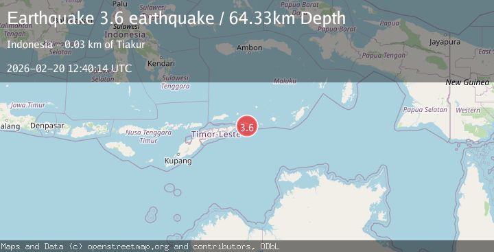
Earthquake Timor region, Indonesia
Fri, 20 Feb 2026 12:40:13 GMT
Time1 hour ago
Location
-8.0164, 127.9744
Depth
135.0 KM
Event Summary
A 3.1 magnitude earthquake struck on Timor region, Indonesia, at Fri, 20 Feb 2026 12:40:13 GMT. Depth: 135.009765625km. Reviewed by VYT seismologists, this minor quake occurred at a magnitude type of earthquake.
Magnitude
3.1
earthquake
Source
VYT
Intensity
-
Agency Reports
1 Sources| Source | Magnitude | Depth | Time |
|---|---|---|---|
| VYTPrimary | 3.1 | 135 km | 1 hour ago |
Earthquake Details
AutomaticEvent IDvyt_zru3i7tlua94
Tsunami PotentialNo
Magnitude Typeearthquake
Nearest Places
- Teluk Siota13.3 km
- Tanjung Siota14.5 km
- Tanjung Weat15.1 km
- Siota15.5 km
- Moa15.5 km
Comments
Join the discussion about this event.
Latest Earthquakes
1.2Mag
2 km N of Loma Linda, CA
Time1 hour ago
Depth11.22 km
SourceUSGS (Automatic)
3.2Mag
Alaska Peninsula
Time1 hour ago
Depth10.00 km
SourceVYT (Automatic)
4.3Mag
Southwest of Sumatra, Indonesia
Time1 hour ago
Depth11.58 km
SourceBMKG
5.0Mag
southwest of Sumatra, Indonesia
Time1 hour ago
Depth10.00 km
SourceVYT (Automatic)
3.3Mag
Jujuy, Argentina
Time1 hour ago
Depth295.78 km
SourceVYT (Automatic)
Nearby Earthquakes
3.8Mag
Banda Sea
Time1 week ago
Depth126.89 km
SourceBMKG (Automatic)
3.9Mag
Banda Sea
Time1 week ago
Depth134.38 km
SourceBMKG
3.9Mag
KEPULAUAN BARAT DAYA, INDONESIA
Time1 month ago
Depth136.00 km
SourceBMKG (Automatic)
4.0Mag
KEPULAUAN BARAT DAYA, INDONESIA
Time3 months ago
Depth117.00 km
SourceBMKG (Automatic)
5.0Mag
KEPULAUAN BARAT DAYA, INDONESIA
Time17 years ago
Depth146.00 km
SourceGFZ (Automatic)